IMAGES TAKEN NEAR TO
Durranhill Road, CARLISLE, CA1 2RQ
Introduction
This page details the photographs taken nearby to Durranhill Road, CA1 2RQ by members of the Geograph project.
The Geograph project started in 2005 with the aim of publishing, organising and preserving representative images for every square kilometre of Great Britain, Ireland and the Isle of Man.

There are currently over 7.5m images from over14,400 individuals and you can help contribute to the project by visiting https://www.geograph.org.uk
Image Map
Images are licensed for reuse under creativecommons.org/licenses/by-sa/2.0
Notes
- Clicking on the map will re-center to the selected point.
- The higher the marker number, the further away the image location is from the centre of the postcode.
Image Listing (20 Images Found)
Images are licensed for reuse under creativecommons.org/licenses/by-sa/2.0
Image
Details
Distance
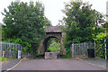
1
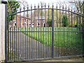
Durranhill Lodge
A brick-built former farmhouse with adjacent barn. Dating from the mid 18th century, it later served as the lodge to nearby Durranhill House. A stone above the front door is inscribed 'Rebuilt 1870'.
Both the house and barn are Grade II listed buildings (see http://www.imagesofengland.org.uk/details/default.aspx?id=386705 and http://www.imagesofengland.org.uk/details/default.aspx?id=386706 ).
Image: © Rose and Trev Clough
Taken: 31 Mar 2017
0.01 miles
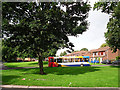
2
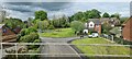
Housing by Durranhill Bridge, Carlisle
Image: © Chris Morgan
Taken: 22 May 2021
0.03 miles
3
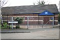
Kingdom Hall of Jehovah's Witnesses
Built in 2002. The entrance is in Moorwood Close.
Image: © Rose and Trev Clough
Taken: 31 Mar 2017
0.06 miles
4
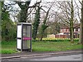
Unusable telephone box, Geltsdale Avenue
The phone was gone, and there was burnt rubbish and aerosol cans inside.
Image: © Rose and Trev Clough
Taken: 31 Mar 2017
0.06 miles
5
Bus waiting at Cumrew Close
The terminus of the number 76 Stagecoach service from St Ann's Hill to Durranhill.
Image: © Rose and Trev Clough
Taken: 18 Sep 2013
0.08 miles
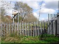
6
Path under the railway at Durranhill
Pedestrian route from Pasture Walk, under the Newcastle-Carlisle Railway, leading to Keenan Park in Harraby.
View from the other side of the bridge here : Image .
Image: © Rose and Trev Clough
Taken: 18 Sep 2013
0.08 miles
7
Fence and old sign at former landfill site
Image: © Rose and Trev Clough
Taken: 31 Mar 2017
0.09 miles
8
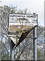
Old sign, Durranhill Sidings Landfill
The advice on opening hours is now redundant, as the site has been restored to grazing land. For more information see Image .
Image: © Rose and Trev Clough
Taken: 31 Mar 2017
0.09 miles
9
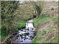
Durranhill Beck, upstream of railway culvert
The stream is flowing towards a culvert, which takes it under the embankment of the Newcastle-Carlisle railway line.
Image: © Rose and Trev Clough
Taken: 31 Mar 2017
0.09 miles
10
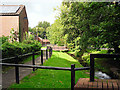
Durranhill Beck
Several bridges cross the stream here at Cumrew Close, in the Durranhill housing estate. Durranhill Beck is a tributary of the River Eden.
Image: © Rose and Trev Clough
Taken: 18 Sep 2013
0.11 miles