IMAGES TAKEN NEAR TO
Harraby Green Road, CARLISLE, CA1 2QB
Introduction
This page details the photographs taken nearby to Harraby Green Road, CA1 2QB by members of the Geograph project.
The Geograph project started in 2005 with the aim of publishing, organising and preserving representative images for every square kilometre of Great Britain, Ireland and the Isle of Man.

There are currently over 7.5m images from over14,400 individuals and you can help contribute to the project by visiting https://www.geograph.org.uk
Image Map
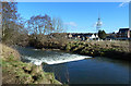
Images are licensed for reuse under creativecommons.org/licenses/by-sa/2.0
Notes
- Clicking on the map will re-center to the selected point.
- The higher the marker number, the further away the image location is from the centre of the postcode.
Image Listing (60 Images Found)
Images are licensed for reuse under creativecommons.org/licenses/by-sa/2.0
Image
Details
Distance
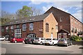
1
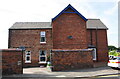
Chertsey Bank face of No. 34 Lazonby Gardens
There is an Ordnance Survey benchmark Image on the right hand end of the high brick wall in the middle of the image at its junction with a low brick wall
Image: © Luke Shaw
Taken: 24 Aug 2019
0.07 miles
2
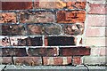
Benchmark on Chertsey Bank wall of No. 34 Lazonby Gardens
Ordnance Survey cut mark benchmark described on the Bench Mark Database at www.bench-marks.org.uk/bm102576
Image: © Luke Shaw
Taken: 24 Aug 2019
0.07 miles
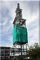
3
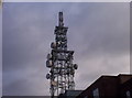
Radio Mast
The BT Radio Mast on Hillcrest Avenue is a prominent landmark.
Image: © Weston Beggard
Taken: 20 Jan 2006
0.10 miles
4

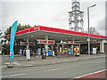
Harraby Green Service Station (1)
Description written December 2018.
Not long after this picture was taken, the business closed down. Most of the site was cleared fairly promptly, but the shop building was not demolished until 2018.
A KFC drive-thru restaurant is being built on the land.
View heading out of town on London Road. The BT radio mast at Hillcrest Avenue is seen on the left.
Image: © Rose and Trev Clough
Taken: 27 Jan 2013
0.12 miles
5
Harraby Green Service Station (2)
Description written December 2018.
This filling station on London Road closed down not long after the photo was taken. Final clearance of the site took place in 2018.
A new KFC drive-thru will be opening here soon. Coincidentally, there is an advert for a KFC Cajun meal on the bus shelter beside the forecourt.
Image: © Rose and Trev Clough
Taken: 27 Jan 2013
0.12 miles
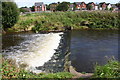
6
The River Petteril
A mid-February view looking across a weir on this river in central Carlisle.
Image: © Mary and Angus Hogg
Taken: 20 Feb 2018
0.12 miles
7
Old industrial buildings at Harraby Green
Now converted to business and residential use, part of Harraby Green Business Park. The location is Tannery Road - a bit of a clue to what was once there. Marked on old maps as a skinnery.
Image: © Rose and Trev Clough
Taken: 30 Apr 2013
0.13 miles
9
Communications mast seen from Hillcrest Avenue
The mast is an Ordnance Survey intersected station trig point, for details see http://trigpointing.uk/trig/9566
Image: © Roger Templeman
Taken: 24 Aug 2019
0.14 miles
10
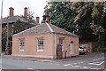
Tollhouse by the A6, London Road, Harraby
Tollhouse by the A6 at junction with High Street, Harraby, in the parish of Carlisle (Carlisle District), The Lodge, No. 258, London Road.
Grade II listed.
List Entry Number: 1217845 https://historicengland.org.uk/listing/the-list/list-entry/1217845
To be surveyed
Milestone Society National ID: CB.CAR01
Image: © Milestone Society
Taken: Unknown
0.14 miles