IMAGES TAKEN NEAR TO
Delagoa Terrace, CARLISLE, CA1 2NY
Introduction
This page details the photographs taken nearby to Delagoa Terrace, CA1 2NY by members of the Geograph project.
The Geograph project started in 2005 with the aim of publishing, organising and preserving representative images for every square kilometre of Great Britain, Ireland and the Isle of Man.

There are currently over 7.5m images from over14,400 individuals and you can help contribute to the project by visiting https://www.geograph.org.uk
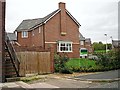
Image Map
Images are licensed for reuse under creativecommons.org/licenses/by-sa/2.0
Notes
- Clicking on the map will re-center to the selected point.
- The higher the marker number, the further away the image location is from the centre of the postcode.
Image Listing (113 Images Found)
Images are licensed for reuse under creativecommons.org/licenses/by-sa/2.0
Image
Details
Distance
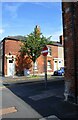
1
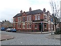
The Linton Holme Hotel
Pub at the corner of Delagoa Street (left) and Lindisfarne Street (right), which opened in 1901.
Image: © Rose and Trev Clough
Taken: 1 Mar 2008
0.01 miles
2
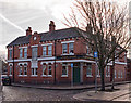
Linton Holme public house, Carlisle - December 2018
Shown as a field on the 1879 OS Map, the "Linton Holme" appears to have been built 1899-1901. It was acquired by the State Management Scheme on 11 August 1916 and sold to Scottish & Newcastle on 17 April 1973. Still trading.
Photograph is for record only - I have no connection with this business and cannot advise on its products or services.
Image: © The Carlisle Kid
Taken: 22 Dec 2018
0.02 miles
3
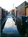
Puddle in a back alley
The alley runs behind the terraced houses of Delagoa Street and Sybil Street.
Image: © Rose and Trev Clough
Taken: 16 Jan 2008
0.03 miles
4
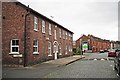
Former railway hostel, Lindisfarne Street
The building on the left is marked on 1960s OS maps https://www.old-maps.co.uk/#/Map/341173/555175/13/101329 as 'Railway Hostel'. Looking at older maps, it appears to date from the early 20th century - then conveniently situated just behind the London Road railway yard (see Image ).
Today it is still a men's hostel, but run by Impact Housing, not the railways.
Image: © Rose and Trev Clough
Taken: 4 Oct 2011
0.05 miles
5

Margaret Creighton Gardens
Thousands of crocus bulbs were planted here in 2007 by Carlisle Housing Association, as a neighbourhood regeneration project. They were put in with a mechanised planter.
The properties were built as housing for the elderly in 1932, and named after the wife of former mayor Archibald Creighton.
Image: © Rose and Trev Clough
Taken: 16 Mar 2008
0.06 miles
6
New houses at Tramside Way (2011)
A housing development called Linton Grove, off Lindisfarne Street.
The homes were built on land previously occupied by Watts Storage Depot, which was established in a former railway yard. A photo taken from the same position in March 2008 shows quite a different scene Image .
Image: © Rose and Trev Clough
Taken: 4 Oct 2011
0.07 miles
7
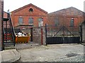
Old engine shed behind Lindisfarne Street (2)
For information about the building, see Image .
When this picture was taken in March 2008, the site (Watts Storage Depot) had approval for a housing development. The buildings were demolished a few months later, but suffered a couple of arson attacks in the intervening period - see BBC News http://news.bbc.co.uk/1/hi/7423221.stm .
Compare this view with one taken from the same spot in October 2011 Image .
Image: © Rose and Trev Clough
Taken: 1 Mar 2008
0.07 miles
8
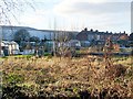
Adelaide Street allotments, January 2008
View from Melbourne Park, looking towards the end of Delagoa Street.
The warehouses on the left are at Watts Yard, a storage business accessed from London Road - see http://www.geograph.org.uk/photo/5267686 . They were demolished a few months after this photo was taken, and houses have been built in their place.
Image: © Rose and Trev Clough
Taken: 16 Jan 2008
0.08 miles
9
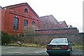
Old engine shed behind Lindisfarne Street (1)
Back of the former engine shed at London Road yard, built by the North Eastern Railway in the late 19th century. The locomotives were transferred to the Canal depot in the 1930s, but the shed yard remained in use by BR until 1963. Not long afterwards it was acquired by J & W Watt, whose business switched from mainly haulage to warehousing and storage in the mid 1980s. Around that time, additional large buildings were erected beside the older sheds.
The engine shed has three gables, and at some time during the mid 20th century the roof of the central section was taken off. It has later been replaced in a more basic style, lacking the round window and stepped brickwork seen on the gables either side.
When this picture was taken (March 2008) the shed was shortly to be demolished, and Watts Storage Depot redeveloped with housing.
See also Image .
Image: © Rose and Trev Clough
Taken: 1 Mar 2008
0.08 miles
10
Junction of Linton Street and Brook Street
There is an Ordnance Survey benchmark Image at the base of the house (No. 2 Linton Street) wall in the right foreground of the image, half way between the black downpipe and the corner of the house
Image: © Luke Shaw
Taken: 24 Aug 2019
0.10 miles