IMAGES TAKEN NEAR TO
Hilltop Heights, London Road, CARLISLE, CA1 2NS
Introduction
This page details the photographs taken nearby to Hilltop Heights, London Road, CA1 2NS by members of the Geograph project.
The Geograph project started in 2005 with the aim of publishing, organising and preserving representative images for every square kilometre of Great Britain, Ireland and the Isle of Man.

There are currently over 7.5m images from over14,400 individuals and you can help contribute to the project by visiting https://www.geograph.org.uk
Image Map
Images are licensed for reuse under creativecommons.org/licenses/by-sa/2.0
Notes
- Clicking on the map will re-center to the selected point.
- The higher the marker number, the further away the image location is from the centre of the postcode.
Image Listing (107 Images Found)
Images are licensed for reuse under creativecommons.org/licenses/by-sa/2.0
Image
Details
Distance
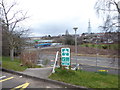
2
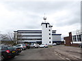
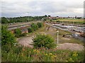
Hilltop Heights from across the railway
A telephoto shot from York Fields, looking over Upperby railway depot.
The Capital Building is the bright white one, The Hilltop Hotel is to the left.
Image: © Rose and Trev Clough
Taken: 2 Oct 2016
0.01 miles
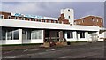
3
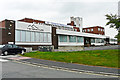
The Swallow Hilltop Hotel
This photo was taken shortly after the hotel closed down - hence the concrete blocks across the entrance. A few months later it reopened under new ownership, now called the Milton Hilltop.
The building was originally a railwaymen's hostel, a stop-over for staff away from home between shifts - compare Image . In 1970 it was converted to a hotel, then called the Hilltop Motor Hotel.
Image: © Rose and Trev Clough
Taken: 28 Sep 2014
0.04 miles
4
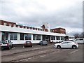
Now the MILTON Hilltop
Also see http://www.geograph.org.uk/photo/4611016
Image: © Basher Eyre
Taken: 31 Mar 2018
0.04 miles
6
Milton Hilltop Hotel
The building was previously a British Railways Staff Hostel. A bolt installed in 1953 on the roof of the white tower was used as an Ordnance Survey triangulation station, see http://trigpointing.uk/trig/11117 for details
Image: © Roger Templeman
Taken: 12 Jan 2022
0.06 miles
7
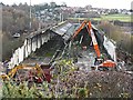
Upperby carriage sheds - demolition in progress
For information, see Image .
Allotments and houses at Cant Crescent in the distance.
Image: © Rose and Trev Clough
Taken: 30 Nov 2016
0.06 miles
8
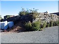
Remains of Hilltop Heights reservoir
See information on other photo
Image: © Brian Norman
Taken: 1 Oct 2015
0.07 miles
9
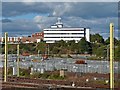
Old railway sheds at Upperby Depot
A view from Hilltop Heights. There are plenty of holes in the roofs of these sheds, which we believe are empty. An impression on the ground below indicates where a circular engine shed (or roundhouse) once stood. We do not know when it was demolished, but it was built in 1948 by the newly nationalised British Railways to replace older sheds http://www.railbrit.co.uk/location.php?loc=Carlisle%20Upperby .
The square tower at the right of the horizon is St. Margaret Mary's RC Church in Currock.
Information update : the long sheds were demolished in 2016 - see Image .
Image: © Rose and Trev Clough
Taken: 1 Aug 2009
0.07 miles
10
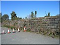
Remains of reservoir wall at Hilltop Heights
Water was once drawn from the River Eden at Stoney Holme and pumped by a beam engine to a reservoir at Hilltop Heights. The pipeline ran along St Aidans Rd and Rydal St into Botchergate and then up London Rd to the reservoir. Parts of the reservoir walls still remain behind the Hilltop Hotel.
Image: © Brian Norman
Taken: 1 Oct 2015
0.07 miles