IMAGES TAKEN NEAR TO
Tyne Street, CARLISLE, CA1 2NP
Introduction
This page details the photographs taken nearby to Tyne Street, CA1 2NP by members of the Geograph project.
The Geograph project started in 2005 with the aim of publishing, organising and preserving representative images for every square kilometre of Great Britain, Ireland and the Isle of Man.

There are currently over 7.5m images from over14,400 individuals and you can help contribute to the project by visiting https://www.geograph.org.uk
Image Map
Images are licensed for reuse under creativecommons.org/licenses/by-sa/2.0
Notes
- Clicking on the map will re-center to the selected point.
- The higher the marker number, the further away the image location is from the centre of the postcode.
Image Listing (145 Images Found)
Images are licensed for reuse under creativecommons.org/licenses/by-sa/2.0
Image
Details
Distance
1
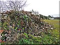
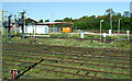
A pile of rubble
Half way up this pile there was an old brick of local interest - see Image .
The location is an area of undeveloped land at Hilltop Heights. Some white bags in the distance are next to the wall of a former reservoir, shown in this photo by another contributor Image .
Image: © Rose and Trev Clough
Taken: 30 Nov 2016
0.04 miles
2
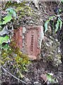
A Kingmoor brick
Seen at Hilltop Heights - location here Image .
The Kingmoor Brick and Tile Works opened in 1896 and closed in the 1960s (Carlisle Encyclopedia http://www.carlisleshistory.co.uk/page33.htm ).
It was located to the west of Kingstown Road, in the vicinity of what is now Moorville Drive on the Lowry Hill housing estate Image . The exact position of the brickworks chimney is recorded, because there happened to be an Ordnance Survey trig point there (now destroyed) - see http://trigpointing.uk/trig/11104?b=0&l=0&c=#map .
Image: © Rose and Trev Clough
Taken: 30 Nov 2016
0.04 miles
3
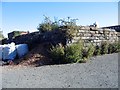
Remains of Hilltop Heights reservoir
See information on other photo
Image: © Brian Norman
Taken: 1 Oct 2015
0.05 miles
4
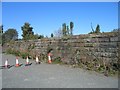
Remains of reservoir wall at Hilltop Heights
Water was once drawn from the River Eden at Stoney Holme and pumped by a beam engine to a reservoir at Hilltop Heights. The pipeline ran along St Aidans Rd and Rydal St into Botchergate and then up London Rd to the reservoir. Parts of the reservoir walls still remain behind the Hilltop Hotel.
Image: © Brian Norman
Taken: 1 Oct 2015
0.05 miles
5
Railway scene at Carlisle
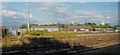
On approach to Carlisle station on a Glasgow bound train from Manchester Airport. A spur leading to the Newcastle and Settle lines can be seen to the right of the shed.
Image: © Thomas Nugent
Taken: 18 Apr 2014
0.08 miles
6
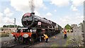
46201 'Princess Elizabeth' at Carlisle
The locomotive with its support carriage has just taken on water from the tanker lorry and is being made ready at Upperby Junction depot for the return journey to Crewe via Settle after hauling the steam excursion north to Carlisle on the west coast main line.
Image: © Greg Fitchett
Taken: 30 Jul 2011
0.08 miles
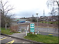
8
St Nicolas Bridge Business Park
St Nicholas Bridge Business Park seen from the WCML.
Image: © Peter McDermott
Taken: 2 Jun 2016
0.09 miles
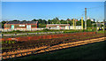
9
Business units by the railway - Carlisle
Image: © Anthony Parkes
Taken: 6 Aug 2014
0.09 miles
10
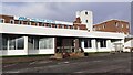
Milton Hilltop Hotel
The building was previously a British Railways Staff Hostel. A bolt installed in 1953 on the roof of the white tower was used as an Ordnance Survey triangulation station, see http://trigpointing.uk/trig/11117 for details
Image: © Roger Templeman
Taken: 12 Jan 2022
0.09 miles