IMAGES TAKEN NEAR TO
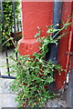
Alexander Street, CARLISLE, CA1 2LH
Introduction
This page details the photographs taken nearby to Alexander Street, CA1 2LH by members of the Geograph project.
The Geograph project started in 2005 with the aim of publishing, organising and preserving representative images for every square kilometre of Great Britain, Ireland and the Isle of Man.

There are currently over 7.5m images from over14,400 individuals and you can help contribute to the project by visiting https://www.geograph.org.uk
Image Map
Images are licensed for reuse under creativecommons.org/licenses/by-sa/2.0
Notes
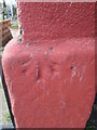
- Clicking on the map will re-center to the selected point.
- The higher the marker number, the further away the image location is from the centre of the postcode.
Image Listing (176 Images Found)
Images are licensed for reuse under creativecommons.org/licenses/by-sa/2.0
Image
Details
Distance
1
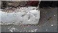
Benchmark on #17 Brook Street
Ordnance Survey pivot benchmark shown as levelled at 59.9 feet above mean sea level on the 1938 1:2500 Map
Image: © Roger Templeman
Taken: 16 Oct 2021
0.03 miles
2
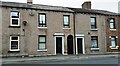
Nos.15, 17,19 Brook Street
There is an Ordnance Survey benchmark Image on the white-painted base of the middle house left of the alley gate between the two house doors
Image: © Roger Templeman
Taken: 16 Oct 2021
0.03 miles
3
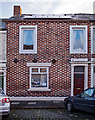
Former "Beerhouse Off-Licence", Orchard Street, Carlisle - December 2018
This unassuming late 19th Century terrace house at 34 Orchard Street was once the "Beerhouse Off-Licence". It was acquired by the State Management Scheme on 1 November 1916 and probably instantly closed. There are signs of alterations around the ground floor window which may date from its conversion to a private dwelling.
Private dwelling with no public access.
Image: © The Carlisle Kid
Taken: 22 Dec 2018
0.05 miles
4
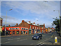
London Road, Carlisle
The road is the A6. The junction on the right enters a retail park. The road to the left of Machine Mart is Brook Street.
Image: © Richard Dorrell
Taken: 25 Jul 2011
0.06 miles
5
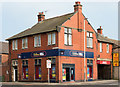
Former "London Tavern" pub - September 2016
Situated on the corner of Alexander Street and London Road (which was the only way to be certain of the location), this started life as the South End Unionist Club. One of the first licensed premises to be acquired by the State Scheme, it was refurbished and reopened in 1916 as the "London Tavern". Returned to private ownership on 2 April 1973 when sold to Greenall Whitley, it closed in 2008.
For a photograph of the pub just after closure, see: Image] .
Photograph is for record only - I have no connection with any business seen in this view and cannot advise on their products or services.
Image: © The Carlisle Kid
Taken: 15 Sep 2016
0.06 miles
6
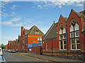
School and Music Centre, Edward Street
All of these buildings were originally built as a school. Today, the building on the right is part of Brook Street Primary School. The rest has been in use as the Carlisle Music Centre since the 1970s. The road is Edward Street, seen from close to its junction with Brook Street.
Image: © Richard Dorrell
Taken: 26 Jul 2011
0.06 miles
7
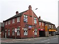
The London Tavern
Former pub at the corner of Alexander Street (left) and London Road, closed about 2008. It opened in 1916, in premises formerly occupied by the South End Unionist Club (Carlisle Encyclopaedia http://www.carlisleshistory.co.uk/page34.htm ).
Since the photo was taken a new door has replaced one of the front windows, as the ground floor is being converted to retail premises.
Image: © Rose and Trev Clough
Taken: 9 Apr 2010
0.06 miles
8
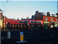
Machine Mart, London Road, Carlisle
A Power tool retailer, located on the corner of London Road and Brook Street, Carlisle.
Image: © Graham Robson
Taken: 4 Nov 2012
0.07 miles
9
Benchmark on #81 London Road
Ordnance Survey pivot benchmark described on the Bench Mark Database at http://www.bench-marks.org.uk/bm38342
Image: © Roger Templeman
Taken: 18 Jun 2011
0.07 miles
10
Ordnance Survey Cut Mark
This OS cut mark can be found on No81 London Road. It marks a point 19.114m above mean sea level.
Image: © Adrian Dust
Taken: 11 Apr 2016
0.07 miles