IMAGES TAKEN NEAR TO
Grey Street, CARLISLE, CA1 2JP
Introduction
This page details the photographs taken nearby to Grey Street, CA1 2JP by members of the Geograph project.
The Geograph project started in 2005 with the aim of publishing, organising and preserving representative images for every square kilometre of Great Britain, Ireland and the Isle of Man.

There are currently over 7.5m images from over14,400 individuals and you can help contribute to the project by visiting https://www.geograph.org.uk
Image Map
Images are licensed for reuse under creativecommons.org/licenses/by-sa/2.0
Notes
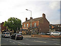
- Clicking on the map will re-center to the selected point.
- The higher the marker number, the further away the image location is from the centre of the postcode.
Image Listing (202 Images Found)
Images are licensed for reuse under creativecommons.org/licenses/by-sa/2.0
Image
Details
Distance
1
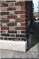
Benchmark on #25 Grey Street
Ordnance Survey cut mark benchmark described on the Bench Mark Database at http://www.bench-marks.org.uk/bm24454
Image: © Roger Templeman
Taken: 12 Jun 2011
0.00 miles
2
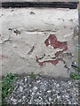
Ordnance Survey Cut Mark
This OS cut mark can be found on No25 Grey Street. It marks a point 18.745m above mean sea level.
Image: © Adrian Dust
Taken: 11 Apr 2016
0.00 miles
3
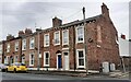
Houses of Grey Street at Flower Street junction
There is an Ordnance Survey benchmark Image on the right hand end of the white skirt which runs along the base of the houses
Image: © Roger Templeman
Taken: 30 Jul 2021
0.01 miles
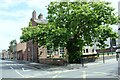
4
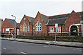
Greystone Community Centre, Close Street
A former school building dating from the 1870s. Originally called St John's, latterly Greystone School, which closed in 1981 (see Carlisle Encyclopaedia http://www.carlisleshistory.co.uk/page29.htm ). Since then, extensions have been added at both ends of the building.
Image: © Rose and Trev Clough
Taken: 3 Jan 2011
0.05 miles
5
St Nicholas Arms public house
Located on the London Road (A6) at the junction with Grey Street.
Image: © Richard Dorrell
Taken: 25 Jul 2011
0.05 miles
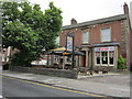
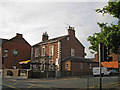
7
St Nicholas Arms, London Road, Carlisle - September 2016
Opened by the State Management Board in 1921, the St Nicholas Arms
was sold to the John Smiths Brewing Group on 9 May 1973. Still trading.
Photograph is for record only - I have no connection with this business and cannot advise on its products or services.
Image: © The Carlisle Kid
Taken: 13 Sep 2016
0.05 miles
8
St Nicholas Arms pub at Grey Street / London Road junction
There is an Ordnance Survey benchmark Image on the wall pier, left hand face, at the wall corner, right of the Grey Street name sign
Image: © Roger Templeman
Taken: 19 Aug 2019
0.05 miles
9
The Cranemakers public house
Located in the London Road (A6) at the junction with Grey Street. There are three pubs at this road junction. Thirsty place?
Image: © Richard Dorrell
Taken: 25 Jul 2011
0.05 miles
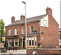
10
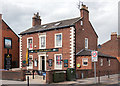
The Cranemakers, Carlisle - August 2016
Built circa 1840 and originally "The Carlton" hotel, it became "The Theakston" public house in 1981. The name was changed to "The Cranemakers" in 1990 after the demise of Cowans, Sheldon & Co., whose works were across the road (demolished 1989 and now retail outlets).
The building is Grade II listed.
The pub web sites gives an interesting potted history of Cowans, Sheldon : http://thecranies.webs.com/history.htm
Photograph is for record only - I have no connection with this business and all queries should be directed through the pub web site.
Image: © The Carlisle Kid
Taken: 9 Aug 2016
0.06 miles