IMAGES TAKEN NEAR TO
Agricola Way, CA1 2FX
Introduction
This page details the photographs taken nearby to Agricola Way, CA1 2FX by members of the Geograph project.
The Geograph project started in 2005 with the aim of publishing, organising and preserving representative images for every square kilometre of Great Britain, Ireland and the Isle of Man.

There are currently over 7.5m images from over14,400 individuals and you can help contribute to the project by visiting https://www.geograph.org.uk
Image Map
Images are licensed for reuse under creativecommons.org/licenses/by-sa/2.0
Notes
- Clicking on the map will re-center to the selected point.
- The higher the marker number, the further away the image location is from the centre of the postcode.
Image Listing (25 Images Found)
Images are licensed for reuse under creativecommons.org/licenses/by-sa/2.0
Image
Details
Distance
1
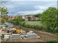
Housing development near Scotby Bridge
Image: © Chris Morgan
Taken: 22 May 2021
0.09 miles
2
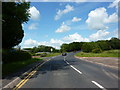
Road junction
Of Durranhill Road, Park Road and Montgomery Road
Image: © Alexander P Kapp
Taken: 16 Jun 2011
0.09 miles
3
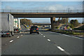
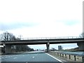
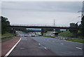
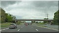
City of Carlisle : The M6 Motorway
Looking north along the M6 Motorway.
Image: © Lewis Clarke
Taken: 22 Apr 2016
0.11 miles
4

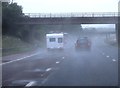
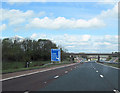
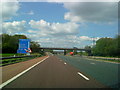
Approaching Junction 43 heading north
M6 motorway
Image: © John Firth
Taken: 9 May 2012
0.12 miles