IMAGES TAKEN NEAR TO
St. Johns Court, Close Street, CARLISLE, CA1 2EZ
Introduction
This page details the photographs taken nearby to St. Johns Court, Close Street, CA1 2EZ by members of the Geograph project.
The Geograph project started in 2005 with the aim of publishing, organising and preserving representative images for every square kilometre of Great Britain, Ireland and the Isle of Man.

There are currently over 7.5m images from over14,400 individuals and you can help contribute to the project by visiting https://www.geograph.org.uk
Image Map
Images are licensed for reuse under creativecommons.org/licenses/by-sa/2.0
Notes
- Clicking on the map will re-center to the selected point.
- The higher the marker number, the further away the image location is from the centre of the postcode.
Image Listing (268 Images Found)
Images are licensed for reuse under creativecommons.org/licenses/by-sa/2.0
Image
Details
Distance
1
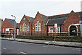
Greystone Community Centre, Close Street
A former school building dating from the 1870s. Originally called St John's, latterly Greystone School, which closed in 1981 (see Carlisle Encyclopaedia http://www.carlisleshistory.co.uk/page29.htm ). Since then, extensions have been added at both ends of the building.
Image: © Rose and Trev Clough
Taken: 3 Jan 2011
0.02 miles
2
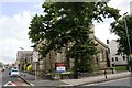
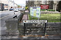
St. John the Evangelist Church at London Road / Close Street junction
There is an Ordnance Survey benchmark Image on the wall pier at the wall corner left of the London Road name sign
Image: © Luke Shaw
Taken: 19 Aug 2019
0.04 miles
3
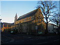
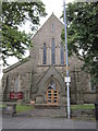
St John The Evangelist Church, London Road, Carlisle
The church of St John The Evangelist, located at the junction of London Road and Close Street, Carlisle.
Image: © Graham Robson
Taken: 4 Nov 2012
0.05 miles
5
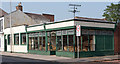
Goodwoods, 17-21 London Road, Carlisle - September 2016
A seemingly long-established furniture and bric-a-brac shop on the London Road.
Photograph is for record only - I have no connection with this business and cannot advise on its products or services.
Image: © The Carlisle Kid
Taken: 15 Sep 2016
0.05 miles
6

Benchmark on corner wall pier at junction of London Road and Close Street
Ordnance Survey cut mark benchmark described on the Bench Mark Database at www.bench-marks.org.uk/bm24453
Image: © Luke Shaw
Taken: 19 Aug 2019
0.06 miles
7
Benchmark on wall corner pier of St John the Evangelist Church
Ordnance Survey cut mark benchmark described on the Bench Mark Database at http://www.bench-marks.org.uk/bm24453
Image: © Roger Templeman
Taken: 12 Jun 2011
0.06 miles
8
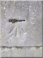
Ordnance Survey Cut Mark
This OS cut mark can be found at the junction of Close Street and Botchergate. It marks a point 18.777m above mean sea level.
Image: © Adrian Dust
Taken: 11 Apr 2016
0.06 miles
10
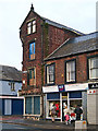
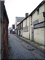
Painted sign, former Walter Willson shop
Walter Willson had a large chain of grocery stores across the north of England. It was in operation from the mid 19th century until 1998, though this shop in London Road had changed hands many years before that.
A few months after this photo was taken the building was done up, and the brickwork rendered over.
Image: © Rose and Trev Clough
Taken: 3 Jan 2008
0.06 miles