IMAGES TAKEN NEAR TO
Barrock Street, CARLISLE, CA1 2EU
Introduction
This page details the photographs taken nearby to Barrock Street, CA1 2EU by members of the Geograph project.
The Geograph project started in 2005 with the aim of publishing, organising and preserving representative images for every square kilometre of Great Britain, Ireland and the Isle of Man.

There are currently over 7.5m images from over14,400 individuals and you can help contribute to the project by visiting https://www.geograph.org.uk
Image Map
Images are licensed for reuse under creativecommons.org/licenses/by-sa/2.0
Notes
- Clicking on the map will re-center to the selected point.
- The higher the marker number, the further away the image location is from the centre of the postcode.
Image Listing (191 Images Found)
Images are licensed for reuse under creativecommons.org/licenses/by-sa/2.0
Image
Details
Distance
1
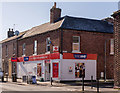
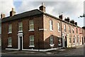
Fusehill Street Convenience Store - April 2018
This appears to be the corner shop and flat sold as Lot 59 in the State Management Scheme 1972 sale document - see: Image] . There is clear evidence of alterations to the building with possible blocked-up entrances at what would have been No's 1 & 3 Fusehill Street, with No. 5 being the yellow framed doorway to the extreme left. It is not yet known if this shop was a replacement for the "Beerhouse Off-Licence" and further research is required.
Photograph is for record only – I have no connection with any business seen in this view and cannot advise on their products or services.
Image: © The Carlisle Kid
Taken: 5 Apr 2018
0.04 miles
2
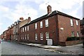
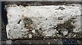
New housing on Rydal Street at junction with Rydal Place
Ordnance Survey records indicate that a benchmark levelled at 18.130m above Newlyn Datum was verified in 1972 on a wall base at this location when the street was Union Street
Image: © Luke Shaw
Taken: 19 Aug 2019
0.04 miles
3
RSPCA Clinic, Close Street
Provides subsidised veterinary treatment for pets whose owners are on benefits https://www.rspca.org.uk/local/cumbria-north-and-east-branch/aboutus/contactus .
Image: © Rose and Trev Clough
Taken: 12 May 2017
0.04 miles
4
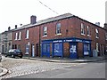
Former "Beerhouse Off-Licence", 86-88 South Street - March 2018
State Management Scheme records show the acquisition of the "Beerhouse Off-Licence" at 86-88 South Street on 1 November 1916. Such small premises were usually instantly closed, but the Sale document of 1972 records these premises, described as a corner shop and flat together with 5 Fusehill Street, offered for sale as Lot 59. There is certainly a corner shop to the left of this view, but whether it was a later purchase as a replacement for 86-88 South Street has yet to be discovered.
86-88 South Street is now a private dwelling with no public access.
Image: © The Carlisle Kid
Taken: 28 Mar 2018
0.04 miles
5
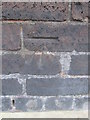
Benchmark on #20 Close Street
Ordnance Survey pivot benchmark described on the Bench Mark Database at www.bench-marks.org.uk/bm74949
Image: © Roger Templeman
Taken: 30 Jul 2021
0.04 miles
6

Decorative brickwork
Located in Fusehill Street, at the junction with Rydal Street. The streets in this area have many rows of terraced housing, and a few terraces are built with two-colour bricks in a decorative pattern, as seen here.
Image: © Richard Dorrell
Taken: 25 Jul 2011
0.05 miles
7
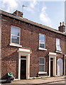
No. 1 Fusehill Street at Rydal Street junction
There is an Ordnance Survey benchmark Image on the corner, right hand face, of the house at the junction
Image: © Luke Shaw
Taken: 8 Aug 2019
0.05 miles
8
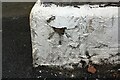
Overpainted benchmark on No. 1 Fusehill Street
Ordnance Survey cut mark benchmark described on the Bench Mark Database at www.bench-marks.org.uk/bm74953
Image: © Luke Shaw
Taken: 8 Aug 2019
0.05 miles
9
Benchmark on #16 Fusehill Street
Ordnance Survey cut mark benchmark described on the Bench Mark Database at http://www.bench-marks.org.uk/bm38339
Image: © Roger Templeman
Taken: 18 Jun 2011
0.05 miles
10
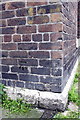
Ordnance Survey Cut Mark
This OS cut mark can be found at the junction of Fusehill Street and Close Street. It marks a point 17.861m above mean sea level.
Image: © Adrian Dust
Taken: 11 Apr 2016
0.05 miles