IMAGES TAKEN NEAR TO
Riverside Way, CARLISLE, CA1 2DZ
Introduction
This page details the photographs taken nearby to Riverside Way, CA1 2DZ by members of the Geograph project.
The Geograph project started in 2005 with the aim of publishing, organising and preserving representative images for every square kilometre of Great Britain, Ireland and the Isle of Man.

There are currently over 7.5m images from over14,400 individuals and you can help contribute to the project by visiting https://www.geograph.org.uk
Image Map
Images are licensed for reuse under creativecommons.org/licenses/by-sa/2.0
Notes
- Clicking on the map will re-center to the selected point.
- The higher the marker number, the further away the image location is from the centre of the postcode.
Image Listing (74 Images Found)
Images are licensed for reuse under creativecommons.org/licenses/by-sa/2.0
Image
Details
Distance
1
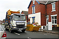
Skip wagon in Greystone Road
Three days after floodwater swamped hundreds of properties in the Warwick Road area of Carlisle, people had started piling up the ruined contents outside. Skips to dispose of these items were being delivered, a few already filled were being taken away.
Image: © Rose and Trev Clough
Taken: 9 Dec 2015
0.05 miles
2
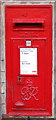
GR VI Postbox, Carlisle
Box CA1 29 at Warwick Road post office.
Image: © David Rogers
Taken: 13 Nov 2009
0.06 miles
3
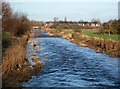
River Petteril flowing through Melbourne Park
View downstream from footbridge towards Botcherby Bridge. The houses are on Warwick Road.
The course of the river here was altered during the late 1950s, it previously ran quite close to properties on Greystone Road. These were liable to flood, so a new straight channel was cut through the park (information from 'Linton Holme - a suburb of Carlisle' by MK Dickens, P3 Publications, 1999).
Image: © Rose and Trev Clough
Taken: 16 Jan 2008
0.09 miles
4
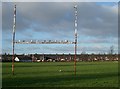
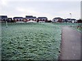
Playing field, Melbourne Park
Houses behind the field are on Greystone Road.
Image: © Rose and Trev Clough
Taken: 16 Jan 2008
0.11 miles
5
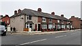
Nos. 262-250 (evens) Warwick Road at Greystone Road junction
Ordnance Survey documents indicate that a benchmark levelled at 15.301m above Newlyn Datum was verified in 1972 on the near corner, left hand face, of the nearest house which is now pebbledashed
Image: © Roger Templeman
Taken: 16 Oct 2021
0.11 miles
9
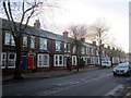
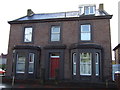
Terraced housing on Warwick Road, Carlisle
Terraced housing on Warwick Road.
Image: © Graham Robson
Taken: 3 Nov 2013
0.12 miles
10
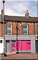
Former "Brunton Park Wine Stores", 265 Warwick Road - March 2016
This part of Warwick Road is believed to date from 1847. At some yet to be discovered date after 1916, the State Management Scheme established an off-licence in these premises, which were sold in 1973 as Lot 28. Thereafter, the trail is currently cold but the licence was clearly surrendered post 1973.
Photograph is for record only – I have no connection with any business seen in this view and cannot advise on their products or services.
Image: © The Carlisle Kid
Taken: 28 Mar 2018
0.12 miles