IMAGES TAKEN NEAR TO
Warwick Road, CARLISLE, CA1 2BX
Introduction
This page details the photographs taken nearby to Warwick Road, CA1 2BX by members of the Geograph project.
The Geograph project started in 2005 with the aim of publishing, organising and preserving representative images for every square kilometre of Great Britain, Ireland and the Isle of Man.

There are currently over 7.5m images from over14,400 individuals and you can help contribute to the project by visiting https://www.geograph.org.uk
Image Map (Loading...)


Getting Data...Please wait
Leaflet Map data © OpenStreetMap
Images are licensed for reuse under creativecommons.org/licenses/by-sa/2.0
Notes
- Clicking on the map will re-center to the selected point.
- The higher the marker number, the further away the image location is from the centre of the postcode.
Image Listing (68 Images Found)
Images are licensed for reuse under creativecommons.org/licenses/by-sa/2.0
Image
Details
Distance
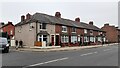
1
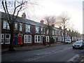
Terraced housing on Warwick Road, Carlisle
Terraced housing on Warwick Road.
Image: © Graham Robson
Taken: 3 Nov 2013
0.04 miles
3
Botcherby Bridge
The bridge was completed in 1932.
Image: © Roger Templeman
Taken: 12 Jun 2011
0.06 miles
4
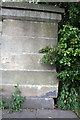
Benchmark on west end of south parapet of Botcherby Bridge
Ordnance Survey cut mark benchmark described on the Bench Mark Database at http://www.bench-marks.org.uk/bm38288
Image: © Roger Templeman
Taken: 12 Jun 2011
0.06 miles
5
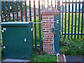
Floodwall art location, beside Brunton Park
This is a floodgate behind Thirlwell Gardens (wider view taken early 2009 shown here http://www.geograph.org.uk/photo/1197309 ). On top of the post is a colourful plaque, one of a series of 40 installed on flood walls around the city.
For a close-up of the design, see Image
Image: © Rose and Trev Clough
Taken: 14 Sep 2014
0.06 miles
6
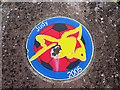
Flood wall art plaque - Judy the goldfish
This is one of 40 plaques installed around the city's new flood walls in 2009 - for information see Image .
The plaque is located on the post of a floodgate next to Carlisle United's football ground at Brunton Park (view of location here http://www.geograph.org.uk/photo/4868946 ). During the floods which devastated Carlisle in 2005, the pitch was deluged with several feet of water. As it was being pumped out, a goldfish was found swimming in a pool at the goalmouth. The fish was identified as Judy, washed out of a flooded house across the road. The little girl who owned it donated her pet as a mascot to the club, where it lived for another five years (see BBC news http://news.bbc.co.uk/sport1/hi/funny_old_game/4183989.stm ).
In December 2015, when the district was again severely flooded, history repeated itself - as the pitch was cleaned up three koi carp were found at the same place in the goalmouth, and a man came to reclaim them ( itv News http://www.itv.com/news/2015-12-10/what-a-catch-carlisle-find-three-koi-carp-in-goalmouth-during-flood-clean-up/ ).
We believe the artwork is by Liam Curtin.
Image: © Rose and Trev Clough
Taken: 14 Sep 2014
0.06 miles
7
Floodgate behind Thirlwell Gardens
Part of the Eden and Petteril flood alleviation scheme, completed in 2008. A flood wall is on the right. The footpath goes between Carlisle United football ground (left) and Stony Holme Golf Course (right), towards the River Petteril.
Image: © Rose and Trev Clough
Taken: 22 Feb 2009
0.06 miles
8
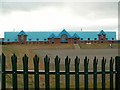
CBS stand and car park, Brunton Park
The Cumberland Building Society stand protected by a flood bank. The height of embankments in the Warwick Road area has been increased since the severe flood of January 2005, when the football pitch was under a couple of metres of water.
Image: © Rose and Trev Clough
Taken: 22 Feb 2009
0.07 miles
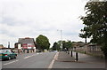
9
Nos. 262-250 (evens) Warwick Road at Greystone Road junction
Ordnance Survey documents indicate that a benchmark levelled at 15.301m above Newlyn Datum was verified in 1972 on the near corner, left hand face, of the nearest house which is now pebbledashed
Image: © Roger Templeman
Taken: 16 Oct 2021
0.07 miles