IMAGES TAKEN NEAR TO
Furze Street, CARLISLE, CA1 2BW
Introduction
This page details the photographs taken nearby to Furze Street, CA1 2BW by members of the Geograph project.
The Geograph project started in 2005 with the aim of publishing, organising and preserving representative images for every square kilometre of Great Britain, Ireland and the Isle of Man.

There are currently over 7.5m images from over14,400 individuals and you can help contribute to the project by visiting https://www.geograph.org.uk
Image Map
Images are licensed for reuse under creativecommons.org/licenses/by-sa/2.0
Notes
- Clicking on the map will re-center to the selected point.
- The higher the marker number, the further away the image location is from the centre of the postcode.
Image Listing (85 Images Found)
Images are licensed for reuse under creativecommons.org/licenses/by-sa/2.0
Image
Details
Distance
1
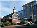
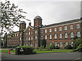
University of Cumbria, Fusehill Street Chapel
For historical background see Image Built c.1901, this was originally a chapel for the Carlisle Workhouse. Today it is used by the University Chaplaincy. The modern building behind the chapel is a student residence. University of Cumbria website : http://www.cumbria.ac.uk/home.aspx
Image: © Rose and Trev Clough
Taken: 1 Mar 2008
0.04 miles
2
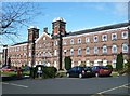
Skiddaw Building, University of Cumbria
The University of Cumbria was established in August 2007, but this building on the Fusehill Street Campus is obviously a bit older. It was opened in 1864 as the Carlisle Union Workhouse, and served as a military hospital during two World Wars. In 1938 the Workhouse buildings were converted to a municipal hospital, which became the City General under the NHS. Patient care transferred to the modern Cumberland Infirmary in the late 1990s and the site was taken over by St. Martin's College, one of the amalgamated institutions of the new University.
For more information on the history of the Carlisle Workhouse, and many others, see : http://www.workhouses.org.uk/
Image: © Rose and Trev Clough
Taken: 1 Mar 2008
0.06 miles
3
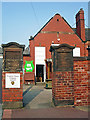
Inscribed gateposts, Norman Street School
At the back entrance to the building, viewed from School Street.
The gateposts are inscribed "Norman Street Council School" and "Infants' Department 1908". There is another gatepost to the left of these, which says "Carlisle Education Committee'.
Image: © Rose and Trev Clough
Taken: 11 Sep 2014
0.07 miles
4
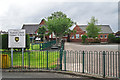
Norman Street Primary School
This is one of the larger primary schools in Cumbria, with 334 pupils in 2015.
The school was opened in 1908 - see Image .
Image: © Rose and Trev Clough
Taken: 5 Jul 2015
0.07 miles
5
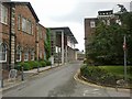
University of Cumbria, Carlisle, Fusehill Street
The university is split over several sites. Fusehill Street offers courses including healthcare, sport, teaching, business, law and social sciences, as well as having student accommodation.
Image: © Richard Dorrell
Taken: 25 Jul 2011
0.07 miles
6
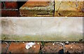
Part of benchmark on Petteril Street wall of No. 38 River Street
Datum line of Ordnance Survey benchmark (the bottom part of the mark now hidden) levelled at 16.033m above Newlyn Datum verified in 1955. See www.bench-marks.org.uk/bm112138
Image: © Luke Shaw
Taken: 24 Aug 2019
0.09 miles
7
Petteril Street face of No. 38 River Street
There is an Ordnance Survey benchmark Image above the pavement level white strip on the recessed section of wall right of the left hand car
Image: © Luke Shaw
Taken: 24 Aug 2019
0.09 miles
9
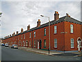
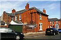
Red brick terraced houses
This part of Carlisle has many streets of terraced houses, presumably all of which were built at approximately the same time. They do not all look the same, however. This terrace in Fusehill Street is unlike most others because it is built of red brick. The junction on the far right is with Grey Street.
Image: © Richard Dorrell
Taken: 25 Jul 2011
0.09 miles
10
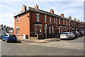
Houses on River Street at Petteril Street junction
Image: © Roger Templeman
Taken: 24 Aug 2019
0.09 miles