IMAGES TAKEN NEAR TO
Riverside View, Warwick Road, CARLISLE, CA1 2BT
Introduction
This page details the photographs taken nearby to Riverside View, Warwick Road, CA1 2BT by members of the Geograph project.
The Geograph project started in 2005 with the aim of publishing, organising and preserving representative images for every square kilometre of Great Britain, Ireland and the Isle of Man.

There are currently over 7.5m images from over14,400 individuals and you can help contribute to the project by visiting https://www.geograph.org.uk
Image Map
Images are licensed for reuse under creativecommons.org/licenses/by-sa/2.0
Notes
- Clicking on the map will re-center to the selected point.
- The higher the marker number, the further away the image location is from the centre of the postcode.
Image Listing (57 Images Found)
Images are licensed for reuse under creativecommons.org/licenses/by-sa/2.0
Image
Details
Distance
1
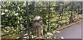
Old Milestone by the A69 in Botcherby
Stone post (plates lost) by the A69, in parish of CARLISLE (CARLISLE District), Brunton Park, Warwick Road, by Lakeland Gate Premier Inn, in iron railings under bushes, on South side of road. Carlisle plate, erected by the Carlisle & Brampton turnpike trust in the 19th century. An earlier photograph can be found here: https://www.geograph.org.uk/photo/5622952
Inscription once read:-
(To / CARLISLE / 1 / MILE) : : (TO / BRAMPTON / 8 / MILES) :
Carved benchmark on right side.
Milestone Society National ID: CU_CLBR01.
Image: © Wayne MacDonald
Taken: 14 Jul 2023
0.05 miles
2
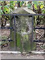
Old Milestone by the A69 in Botcherby
Stone post (plates lost) by the A69, in parish of CARLISLE (CARLISLE District), Brunton Park, Warwick Road, by Lakeland Gate Premier Inn, in iron railings under bushes, on South side of road. Carlisle plate, erected by the Carlisle & Brampton turnpike trust in the 19th century.
Inscription once read:-
(To / CARLISLE / 1 / MILE) : : (TO / BRAMPTON / 8 / MILES) :
Carved benchmark on right side.
Milestone Society National ID: CU_CLBR01.
Image: © CF Smith
Taken: 27 Nov 2009
0.05 miles
3
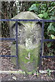
Benchmarked milestone on south side of Warwick Road
The milestone has had its mileage plates removed, originally indicating Carlisle 1 and Brampton 8. The Ordnance Survey cut mark benchmark visible on the right hand side of the stone is described on the Bench Mark Database at http://www.bench-marks.org.uk/bm38280
Image: © Roger Templeman
Taken: 12 Jun 2011
0.05 miles
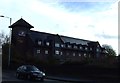
5
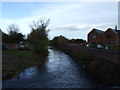
Looking east along Warwick Road passing motel
There is a milestone Image with an OS benchmark in the fence in the middle of the image
Image: © Luke Shaw
Taken: 16 Nov 2019
0.06 miles
6
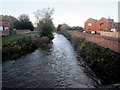
River Petteril, Carlisle
Looking downstream along the River Petteril from Botcherby Bridge.
Image: © Graham Robson
Taken: 3 Nov 2013
0.06 miles
7
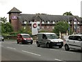
Premier Inn, Carlisle Central
Beside a busy A69, Warwick Road.
Image: © Richard Sutcliffe
Taken: 14 Jun 2019
0.07 miles
9
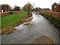
River Petteril, Carlisle
View from Botcherby Bridge showing part of the recently constructed Eden and Petteril Flood Defences.
Image: © David Rogers
Taken: 22 Jan 2010
0.07 miles
10
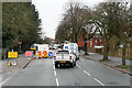
Road Works on Warwick Road
The A69 into Carlisle.
Image: © David Dixon
Taken: 2 Mar 2020
0.08 miles