IMAGES TAKEN NEAR TO
Rosthwaite, KESWICK, CA12 5XB
Introduction
This page details the photographs taken nearby to CA12 5XB by members of the Geograph project.
The Geograph project started in 2005 with the aim of publishing, organising and preserving representative images for every square kilometre of Great Britain, Ireland and the Isle of Man.

There are currently over 7.5m images from over14,400 individuals and you can help contribute to the project by visiting https://www.geograph.org.uk
Image Map
Images are licensed for reuse under creativecommons.org/licenses/by-sa/2.0
Notes
- Clicking on the map will re-center to the selected point.
- The higher the marker number, the further away the image location is from the centre of the postcode.
Image Listing (102 Images Found)
Images are licensed for reuse under creativecommons.org/licenses/by-sa/2.0
Image
Details
Distance
1
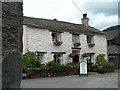
![Rosthwaite buildings [2]](https://s1.geograph.org.uk/geophotos/06/23/67/6236737_0c670e33_120x120.jpg)
Rosthwaite buildings [2]
A fine detached house in the village.
Image: © Michael Dibb
Taken: 23 Jun 2019
0.01 miles
3
![Rosthwaite buildings [1]](https://s0.geograph.org.uk/geophotos/06/23/67/6236736_f9ce71cc_120x120.jpg)
Rosthwaite buildings [1]
The Borrowdale Institute also serves as Rosthwaite village hall.
Image: © Michael Dibb
Taken: 23 Jun 2019
0.03 miles
4
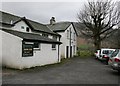
Cottages opposite the Scafell Hotel, Rosthwaite
Image: © Chris Holifield
Taken: 15 Feb 2015
0.03 miles
5
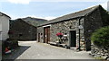
Borrowdale Institute
The village hall; including all day car parking for walkers.
Image: © Mick Garratt
Taken: 17 Mar 2007
0.03 miles
7
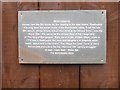
Rosthwaite plaque
The plaque reads "Rosthwaite. Named from the Old Norse for 'the clearing in the rose thorns'. Rosthwaite has long been the social centre of the Borrowdale Valley. In the late 18th century thirsty miners slaked their thirst at the Miners Arms - now the Royal Oak - the venue for the annual ritual of the inauguration of 'The King of Borrowdale'. Early travel writer, William Gilpin, wrote in 1776 that in Rosthwaite 'the sons and daughters of simplicity enjoy health, peace and contentment'. The village has been home to many Borrowdale characters like the infamous 19th century smuggler of wad - black lead - 'Black Sal'.
Image: © Michael Dibb
Taken: 23 Jun 2019
0.04 miles
8
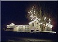
Rosthwaite Institute
Christmas lights in the dark days of winter
Image: © Neil Dowie
Taken: 7 Dec 2005
0.04 miles
9
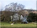
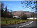
Sheep in field at Rosthwaite
Beyond the field are houses of the village away from the road through Borrowdale. The mountain slope in the distance will rise ultimately to Dale Head but the area in view seems to be named at least in part as High Scawdel.
Image: © Trevor Littlewood
Taken: 21 Feb 2017
0.04 miles
10
![Rosthwaite buildings [3]](https://s0.geograph.org.uk/geophotos/06/23/67/6236740_6fda6c0c_120x120.jpg)
Rosthwaite buildings [3]
Yew Tree Farmhouse is 17th century with a 19th century addition on the left. The house has some original internal features. Listed, grade II, with details at: https://historicengland.org.uk/listing/the-list/list-entry/1107935
Image: © Michael Dibb
Taken: 23 Jun 2019
0.04 miles