IMAGES TAKEN NEAR TO
Watendlath, KESWICK, CA12 5UW
Introduction
This page details the photographs taken nearby to CA12 5UW by members of the Geograph project.
The Geograph project started in 2005 with the aim of publishing, organising and preserving representative images for every square kilometre of Great Britain, Ireland and the Isle of Man.

There are currently over 7.5m images from over14,400 individuals and you can help contribute to the project by visiting https://www.geograph.org.uk
Image Map
Images are licensed for reuse under creativecommons.org/licenses/by-sa/2.0
Notes
- Clicking on the map will re-center to the selected point.
- The higher the marker number, the further away the image location is from the centre of the postcode.
Image Listing (147 Images Found)
Images are licensed for reuse under creativecommons.org/licenses/by-sa/2.0
Image
Details
Distance
1
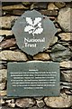
National Trust, Watendlath
Sign on an exterior wall.
Image: © Peter Jeffery
Taken: 11 May 2018
0.00 miles
2
![Walk from Rosthwaite to Watendlath [38]](https://s1.geograph.org.uk/geophotos/06/23/39/6233925_5b165a65_120x120.jpg)
Walk from Rosthwaite to Watendlath [38]
Caffle House, a former farmhouse is now a house and cafe. Built in the late 17th century with 20th century alterations. Listed, grade II, with details at: https://historicengland.org.uk/listing/the-list/list-entry/1119605
The National Trust owned hamlet of Watendlath set in a hanging valley at 847 feet (258 metres) on the edge of a tarn marks the end of the first part of a circular route based on Rosthwaite.
Image: © Michael Dibb
Taken: 23 Jun 2019
0.00 miles
3
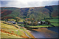
Approaching Watendlath on the path from Borrowdale
A small hamlet that is most enjoyably approached on foot from Rosthwaite.
Image: © Julian Paren
Taken: Unknown
0.00 miles
4
![Walk from Rosthwaite to Watendlath [39]](https://s1.geograph.org.uk/geophotos/06/23/39/6233929_9d7180a2_120x120.jpg)
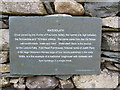
Walk from Rosthwaite to Watendlath [39]
A plaque on the side of Caffle House. It reads: "Watendlath. Once owned by the monks of Fountains Abbey the hamlet sits high between the Borrowdale and Thirlmere Valleys. The name came from the old Norse 'vatn-endhi-hlada' water end barn. Watendlath Beck is the source of the Lodore Falls. Fold End Farmhouse, fictional home of Judith Paris in Sir Hugh Walpole's Herries saga of four novels published in the early 1930s, is a fine example of a traditional 'longhouse' with domestic and farm buildings in a single block."
The National Trust owned hamlet of Watendlath set in a hanging valley at 847 feet (258 metres) on the edge of a tarn marks the end of the first part of a circular route based on Rosthwaite.
Image: © Michael Dibb
Taken: 23 Jun 2019
0.01 miles
5
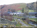
Approaching Watendlath
Track descending into Watendlath from the south west.
Image: © Irene Cockett
Taken: 19 Dec 2006
0.01 miles
7
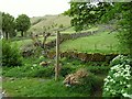
Bridleway signpost, Watendlath
The sign says "Public Bridleway, Armboth 2 miles, Wythburn 4 miles".
Image: © Rose and Trev Clough
Taken: 10 May 2011
0.01 miles
8
Writing on the wall - WATENDLATH
Written on toilet wall [outside] at Watendlath, viewed from the National Trust Car Park.
Image: © Tom Howard
Taken: 7 Aug 2013
0.01 miles
9
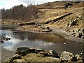
Watendlath Ford
This ford is found at the approach to Watendlath Tarn.
Image: © Ann Walton
Taken: 13 Mar 2013
0.01 miles
10
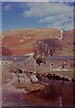
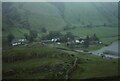
Watendlath Farm
An isolated farmstead above Derwentwater. Goat Crag in the centre and left background. Raise Gill on extreme right background. Stream in foreground runs from Watendlath Tarn.
Image: © N T Stobbs
Taken: Unknown
0.02 miles