IMAGES TAKEN NEAR TO
Borrowdale, KESWICK, CA12 5UU
Introduction
This page details the photographs taken nearby to CA12 5UU by members of the Geograph project.
The Geograph project started in 2005 with the aim of publishing, organising and preserving representative images for every square kilometre of Great Britain, Ireland and the Isle of Man.

There are currently over 7.5m images from over14,400 individuals and you can help contribute to the project by visiting https://www.geograph.org.uk
Image Map
Images are licensed for reuse under creativecommons.org/licenses/by-sa/2.0
Notes
- Clicking on the map will re-center to the selected point.
- The higher the marker number, the further away the image location is from the centre of the postcode.
Image Listing (83 Images Found)
Images are licensed for reuse under creativecommons.org/licenses/by-sa/2.0
Image
Details
Distance
1
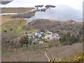
Mary Mount Hotel and the head of Derwent Water
Seen from the aptly-named Surprise View on the Watendlath Road. The River Derwent forms a delta jutting into the head of the lake.
Image: © Oliver Dixon
Taken: 10 Mar 2016
0.01 miles
3
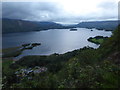
Last light over Derwent Water
This is the view from Surprise View with the evening light rapidly fading. Derwent Water is directly below with its various islands in plain view. The nearest one is St Herbert's Island. Skiddaw is towards the right in the distance with its top covered in cloud. Bassenthwaite Lake can just be seen in the far distance.
Image: © Marathon
Taken: 27 Aug 2018
0.01 miles
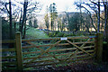
5
The path by the B5289
Fortunately for those walking right round Derwent Water (about 9.5 miles in all), for most of the time that the B5289 hugs the east shore of the lake, there is an accompanying path to keep walkers and traffic separate.
Image: © Gordon Brown
Taken: 29 Jan 2017
0.04 miles
6

Surprise View, above Derwent Water
An excellent viewing point over Derwent Water.
Image: © Brian Clift
Taken: 17 Apr 2010
0.07 miles
7
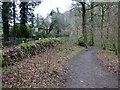
Footpath through Lodore Hotel
On my map this is supposed to be a Permissive path to avoid using the road. On the latest O.S. mapping it's classed as a Public Footpath.
Either way its use is not welcoming and the 'bridge' over the beck just beyond the gate is very precarious.
Image: © Mick Garratt
Taken: 17 Jan 2022
0.08 miles
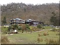
8
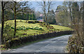
B5289 near Lodore Wood
Approaching the Lodore Falls Hotel.
Image: © Brian Clift
Taken: 17 Apr 2010
0.09 miles
9
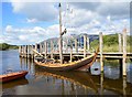
Waiting for Ferry
Replica Viking Ship at Lodore Landing stage
Image: © Malcolm Sandilands
Taken: 10 Sep 2013
0.10 miles
10
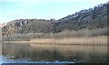
Reedbed on Derwentwater's shore at Lodore
With Lodore Wood behind.
Image: © Christine Johnstone
Taken: 24 Mar 2018
0.10 miles