IMAGES TAKEN NEAR TO
Longcroft, KESWICK, CA12 5TE
Introduction
This page details the photographs taken nearby to Longcroft, CA12 5TE by members of the Geograph project.
The Geograph project started in 2005 with the aim of publishing, organising and preserving representative images for every square kilometre of Great Britain, Ireland and the Isle of Man.

There are currently over 7.5m images from over14,400 individuals and you can help contribute to the project by visiting https://www.geograph.org.uk
Image Map
Images are licensed for reuse under creativecommons.org/licenses/by-sa/2.0
Notes
- Clicking on the map will re-center to the selected point.
- The higher the marker number, the further away the image location is from the centre of the postcode.
Image Listing (75 Images Found)
Images are licensed for reuse under creativecommons.org/licenses/by-sa/2.0
Image
Details
Distance
1
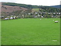
Braithwaite village
As seen from just west of Newlands Beck Bridge.
Image: © M J Richardson
Taken: 16 Apr 2011
0.02 miles
3
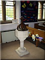
St Hubert's Church, Braithwaite, Font
Image: © Alexander P Kapp
Taken: 5 Sep 2007
0.05 miles
4
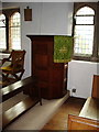
St Hubert's Church, Braithwaite, Pulpit
Image: © Alexander P Kapp
Taken: 5 Sep 2007
0.05 miles
5
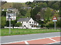
Pedestrians crossing may be photographed
The A66 Keswick-Cockermouth road at Braithwaite.
Image: © M J Richardson
Taken: 16 Apr 2011
0.05 miles
6
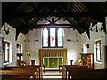
St Hubert's Church, Braithwaite, Interior
Image: © Alexander P Kapp
Taken: 5 Sep 2007
0.05 miles
8
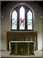
St Hubert's Church, Braithwaite, Interior
Image: © Alexander P Kapp
Taken: 5 Sep 2007
0.06 miles
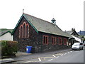
9

Longcroft
Housing on the eastern edge of Braithwaite.
Image: © Ian Capper
Taken: 27 Sep 2018
0.06 miles
10
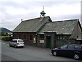
Approaching Braithwaite
On the road from Newlands.
Image: © Brian Clift
Taken: 17 Apr 2010
0.07 miles