IMAGES TAKEN NEAR TO
Braithwaite, KESWICK, CA12 5SZ
Introduction
This page details the photographs taken nearby to CA12 5SZ by members of the Geograph project.
The Geograph project started in 2005 with the aim of publishing, organising and preserving representative images for every square kilometre of Great Britain, Ireland and the Isle of Man.

There are currently over 7.5m images from over14,400 individuals and you can help contribute to the project by visiting https://www.geograph.org.uk
Image Map
Images are licensed for reuse under creativecommons.org/licenses/by-sa/2.0
Notes
- Clicking on the map will re-center to the selected point.
- The higher the marker number, the further away the image location is from the centre of the postcode.
Image Listing (68 Images Found)
Images are licensed for reuse under creativecommons.org/licenses/by-sa/2.0
Image
Details
Distance
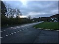
1
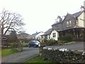
Braithwaite from Station Road
Station Road is an intuitive naming, since no name is apparent, but it leads from the A66 to the Station Master's House on the line of the old railway.
Image: © M J Richardson
Taken: 16 Apr 2011
0.07 miles
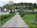
4
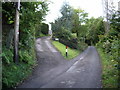
Access road to Wychwood, Shotover and Windrush - houses in Braithwaite
Image: © Alexander P Kapp
Taken: 3 Oct 2007
0.08 miles
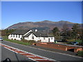
7
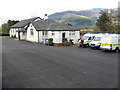
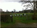
Royal Air Force Mountain Rescue Post
On the A66 at Braithwaite.
Image: © M J Richardson
Taken: 16 Apr 2011
0.11 miles
8
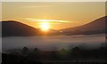
Cloud inversion at sunrise, Braithwaite Howe
Image: © Iain Lees
Taken: 12 Sep 2009
0.12 miles