IMAGES TAKEN NEAR TO
Thornthwaite, KESWICK, CA12 5SL
Introduction
This page details the photographs taken nearby to CA12 5SL by members of the Geograph project.
The Geograph project started in 2005 with the aim of publishing, organising and preserving representative images for every square kilometre of Great Britain, Ireland and the Isle of Man.

There are currently over 7.5m images from over14,400 individuals and you can help contribute to the project by visiting https://www.geograph.org.uk
Image Map
Images are licensed for reuse under creativecommons.org/licenses/by-sa/2.0
Notes
- Clicking on the map will re-center to the selected point.
- The higher the marker number, the further away the image location is from the centre of the postcode.
Image Listing (18 Images Found)
Images are licensed for reuse under creativecommons.org/licenses/by-sa/2.0
Image
Details
Distance
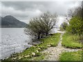
2
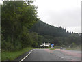
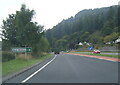
A main road, a lake and a misty fellside
The A66 at Beck Wythop with Ullock Pike partly in view across Bassenthwaite Lake, the only 'Lake' in the Lake District.
Image: © Jim Barton
Taken: 24 Jan 2011
0.06 miles
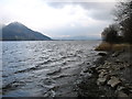
3
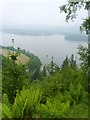
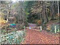
Bassenthwaite Lake
On the forest track in King's Wood looking down the steep valley of Beck Wythop towards the lake.
Image: © Michael Graham
Taken: 6 Jun 2010
0.07 miles
7
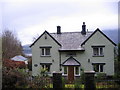
Forest Lodge.
A foresters house with Bassenthwaite lake behind it.
Image: © John Holmes
Taken: 3 Dec 2005
0.10 miles
10
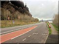
Bassenthwaite Lake
Dodd (502m high in Image) is seen on the far side of the lake, to the left of the photo.
Image: © David Purchase
Taken: 18 Mar 2013
0.17 miles