IMAGES TAKEN NEAR TO
Coleridge Court, KESWICK, CA12 5QE
Introduction
This page details the photographs taken nearby to Coleridge Court, CA12 5QE by members of the Geograph project.
The Geograph project started in 2005 with the aim of publishing, organising and preserving representative images for every square kilometre of Great Britain, Ireland and the Isle of Man.

There are currently over 7.5m images from over14,400 individuals and you can help contribute to the project by visiting https://www.geograph.org.uk
Image Map
Images are licensed for reuse under creativecommons.org/licenses/by-sa/2.0
Notes
- Clicking on the map will re-center to the selected point.
- The higher the marker number, the further away the image location is from the centre of the postcode.
Image Listing (525 Images Found)
Images are licensed for reuse under creativecommons.org/licenses/by-sa/2.0
Image
Details
Distance
1
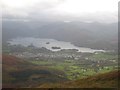
Derwent Water and Keswick seen from the path to Skiddaw
Looking down from the path to Skiddaw from near Jenkin Hill towards Keswick and Derwent Water.
Image: © Graham Robson
Taken: 3 Nov 2009
0.06 miles
2
![Keswick buildings [5]](https://s1.geograph.org.uk/geophotos/06/21/70/6217017_d71aa5da_120x120.jpg)
Keswick buildings [5]
These buildings were formerly part of Keswick School and have been redeveloped for housing.
Image: © Michael Dibb
Taken: 20 Jun 2019
0.06 miles
3
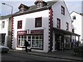
Bookends, Keswick
It is located at Main Street - more at http://www.keswick.org/estdetails.asp?id=1054639893
Image: © Kenneth Allen
Taken: 7 Oct 2009
0.06 miles
4
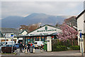
Main Street, Keswick
View of the Co Op store near the junction of Main Street and Tithebarn Road.
Image: © Brian Clift
Taken: 17 Apr 2010
0.06 miles
6
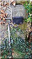
Ordnance Survey Cut Mark
This OS cut mark can be found on No32 Stranger Street. It marks a point 91.710m above mean sea level.
Image: © Adrian Dust
Taken: 14 Sep 2022
0.07 miles
8
![Keswick buildings [6]](https://s2.geograph.org.uk/geophotos/06/21/70/6217018_190cc34f_120x120.jpg)
Keswick buildings [6]
These buildings were formerly part of Keswick School and have been redeveloped as the Rawnsley Centre.
Image: © Michael Dibb
Taken: 20 Jun 2019
0.07 miles
9
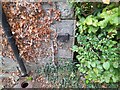
Benchmark on NE side of #32 Stanger Street
Ordnance Survey cut mark benchmark levelled at 91.710m above Newlyn Datum in 1970
Image: © Roger Templeman
Taken: 8 Apr 2024
0.07 miles
10
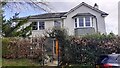
Lane along NE face of #32 Stanger Street
There is an Ordnance Survey benchmark Image on the near corner, lane face, of the house
Image: © Roger Templeman
Taken: 8 Apr 2024
0.08 miles