IMAGES TAKEN NEAR TO
Limepots Road, KESWICK, CA12 5PD
Introduction
This page details the photographs taken nearby to Limepots Road, CA12 5PD by members of the Geograph project.
The Geograph project started in 2005 with the aim of publishing, organising and preserving representative images for every square kilometre of Great Britain, Ireland and the Isle of Man.

There are currently over 7.5m images from over14,400 individuals and you can help contribute to the project by visiting https://www.geograph.org.uk
Image Map
Images are licensed for reuse under creativecommons.org/licenses/by-sa/2.0
Notes
- Clicking on the map will re-center to the selected point.
- The higher the marker number, the further away the image location is from the centre of the postcode.
Image Listing (116 Images Found)
Images are licensed for reuse under creativecommons.org/licenses/by-sa/2.0
Image
Details
Distance
1
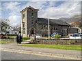
Keswick, Our Lady Of Lourdes Catholic Church
Image: © David Dixon
Taken: 12 Apr 2014
0.04 miles
2
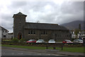
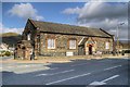
Catholic church
Our Lady of the Lakes church was built in 1928.
Image: © Michael Dibb
Taken: 20 Jun 2019
0.04 miles
3
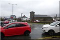
Road junction and Church
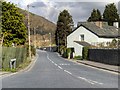
Looking across Crosthwaite Road at the junction of High Hill.
Image: © DS Pugh
Taken: 26 Mar 2016
0.04 miles
6
Our Lady of Lourdes Catholic Church, Keswick
Image: © David Dixon
Taken: 12 Apr 2014
0.04 miles
7
![Keswick buildings [4]](https://s3.geograph.org.uk/geophotos/06/21/70/6217015_72302341_120x120.jpg)
Keswick buildings [4]
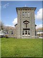
Built in 1833 as a Sunday School, this fine building is now a social centre. Listed, grade II, with details at: https://historicengland.org.uk/listing/the-list/list-entry/1137339
Image: © Michael Dibb
Taken: 20 Jun 2019
0.06 miles
8
![Keswick houses [5]](https://s0.geograph.org.uk/geophotos/06/21/70/6217016_ee9f3772_120x120.jpg)
Keswick houses [5]
A glimpse of Greta Hall through the entrance gates. Now holiday accommodation for up to 20 people this late 18th century house has some original internal features. The hall has been the home of the poets Samuel Taylor Coleridge and Robert Southey. Between 1872 and 1887 it was a girls’ school. In 1909 it became a girls’ boarding house as part of Keswick School and remained as such until 1994. Listed, grade II*, with details at: https://historicengland.org.uk/listing/the-list/list-entry/1144699
Image: © Michael Dibb
Taken: 20 Jun 2019
0.06 miles
9
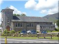
Crosthwaite Sunday School
The former Crosthwaite Sunday School building stands on the Corner of High Hill and Crosthwaite Roadin Keswick. It is a single-storey stone rubble and slate building with a slate roof. It has gabled porch with pointed arched doorway and spandrel carrying the inscription “Crosthwaite Sunday School 1833”. It is now used as the St Herbert Social Centre.
The building is Grade II listed building (English Heritage Building ID: 71778 http://www.britishlistedbuildings.co.uk/en-71778-crosthwaite-sunday-school-keswick-cumbria British Listed Buildings).
Image: © David Dixon
Taken: 12 Apr 2014
0.07 miles
10

River Greta from High Hill
Looking upstream along the River Greta. Crosthwaite road is on the left.
Image: © DS Pugh
Taken: 26 Mar 2016
0.07 miles