IMAGES TAKEN NEAR TO
High Hill, KESWICK, CA12 5NY
Introduction
This page details the photographs taken nearby to High Hill, CA12 5NY by members of the Geograph project.
The Geograph project started in 2005 with the aim of publishing, organising and preserving representative images for every square kilometre of Great Britain, Ireland and the Isle of Man.

There are currently over 7.5m images from over14,400 individuals and you can help contribute to the project by visiting https://www.geograph.org.uk
Image Map
Images are licensed for reuse under creativecommons.org/licenses/by-sa/2.0
Notes
- Clicking on the map will re-center to the selected point.
- The higher the marker number, the further away the image location is from the centre of the postcode.
Image Listing (128 Images Found)
Images are licensed for reuse under creativecommons.org/licenses/by-sa/2.0
Image
Details
Distance
1
![Keswick houses [4]](https://s0.geograph.org.uk/geophotos/06/21/70/6217008_8225226c_120x120.jpg)
Keswick houses [4]
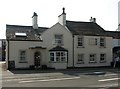
Lakeland View at number 13 High Hill is a 17th century former toll cottage. Now a bed and breakfast establishment.
Image: © Michael Dibb
Taken: 20 Jun 2019
0.00 miles
2
Tollhouse - Lakeland View, High Hill, Keswick
Tollhouse by the A5271, in the parish of Keswick (Allerdale District), Lakeland View, High Hill.
To be surveyed
Milestone Society National ID: CB.KES03
Image: © Milestone Society
Taken: Unknown
0.00 miles
3
![Drinking fountain [1]](https://s1.geograph.org.uk/geophotos/06/21/70/6217009_91b5fe6e_120x120.jpg)
Drinking fountain [1]
Tucked into the flood retaining wall of the River Greta is this drinking fountain.
The plaque Image records that it was one of several provided by Samuel Ladyman.
Image: © Michael Dibb
Taken: 20 Jun 2019
0.01 miles
4
![Drinking fountain [2]](https://s3.geograph.org.uk/geophotos/06/21/70/6217011_8148d9a1_120x120.jpg)
Drinking fountain [2]
The plaque alongside the drinking fountain Image on High Hill.
Image: © Michael Dibb
Taken: 20 Jun 2019
0.01 miles

6

Keswick : High Hill A5271
Looking along High Hill.
Image: © Lewis Clarke
Taken: 26 Sep 2019
0.01 miles
7
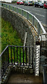
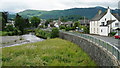
Flood Defences in Keswick
The River Greta lies immediately to the left of this location.
Image: © Peter Trimming
Taken: 4 Jul 2015
0.02 miles
8
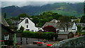
View From Keswick
With a school in the foreground, and the lower slopes of Skiddaw in the distance.
Image: © Peter Trimming
Taken: 4 Jul 2015
0.02 miles
9
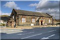
Crosthwaite Sunday School
The former Crosthwaite Sunday School building stands on the Corner of High Hill and Crosthwaite Roadin Keswick. It is a single-storey stone rubble and slate building with a slate roof. It has gabled porch with pointed arched doorway and spandrel carrying the inscription “Crosthwaite Sunday School 1833”. It is now used as the St Herbert Social Centre.
The building is Grade II listed building (English Heritage Building ID: 71778 http://www.britishlistedbuildings.co.uk/en-71778-crosthwaite-sunday-school-keswick-cumbria British Listed Buildings).
Image: © David Dixon
Taken: 12 Apr 2014
0.02 miles
10
River Greta
Looking towards the centre of Keswick and showing the flood defences.
Image: © Peter Trimming
Taken: 4 Jul 2015
0.02 miles