IMAGES TAKEN NEAR TO
Esme Garden, KESWICK, CA12 5JQ
Introduction
This page details the photographs taken nearby to Esme Garden, CA12 5JQ by members of the Geograph project.
The Geograph project started in 2005 with the aim of publishing, organising and preserving representative images for every square kilometre of Great Britain, Ireland and the Isle of Man.

There are currently over 7.5m images from over14,400 individuals and you can help contribute to the project by visiting https://www.geograph.org.uk
Image Map
Images are licensed for reuse under creativecommons.org/licenses/by-sa/2.0
Notes
- Clicking on the map will re-center to the selected point.
- The higher the marker number, the further away the image location is from the centre of the postcode.
Image Listing (627 Images Found)
Images are licensed for reuse under creativecommons.org/licenses/by-sa/2.0
Image
Details
Distance
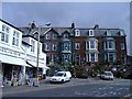
1

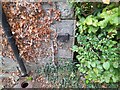
Lane along NE face of #32 Stanger Street
There is an Ordnance Survey benchmark Image on the near corner, lane face, of the house
Image: © Roger Templeman
Taken: 8 Apr 2024
0.02 miles
2
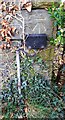
Ordnance Survey Cut Mark
This OS cut mark can be found on No32 Stranger Street. It marks a point 91.710m above mean sea level.
Image: © Adrian Dust
Taken: 14 Sep 2022
0.02 miles

4
Benchmark on NE side of #32 Stanger Street
Ordnance Survey cut mark benchmark levelled at 91.710m above Newlyn Datum in 1970
Image: © Roger Templeman
Taken: 8 Apr 2024
0.02 miles
6
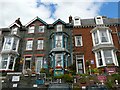
Tall guest houses
A closer view of Image .
Image: © Rose and Trev Clough
Taken: 12 Jun 2010
0.03 miles
8
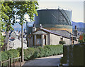
Millbank, Keswick in 1971
This picture shows the view south-east from Millbank in Keswick when the gas holders were still in use, storing natural gas for town distribution. Exact date not recorded, but obviously summer, 1971.
Compare with Image taken nearly 46 years later, and Image, Image looking at the gas works site in the opposite direction.
Image: © John Carter
Taken: Unknown
0.04 miles
9
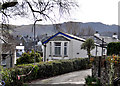
View south-east from Millbank, Keswick in 2017
This picture taken to compare with Image taken in 1971, when two large gasholders were still in use storing natural gas for town distribution. Compare also Image and Image
The red tape bottom left is to protect the work site for the replacement of the footbridge (Knight's Bridge) carried away in the Storm 'Desmond' on 5th December 2015.
Image: © John Carter
Taken: 5 Mar 2017
0.04 miles
10
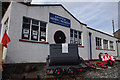
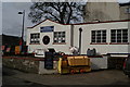
Keswick Mining Museum
Shortly before closure in September 2012.
Image: © Ian Taylor
Taken: 15 Sep 2012
0.04 miles