IMAGES TAKEN NEAR TO
Main Street, KESWICK, CA12 5JJ
Introduction
This page details the photographs taken nearby to Main Street, CA12 5JJ by members of the Geograph project.
The Geograph project started in 2005 with the aim of publishing, organising and preserving representative images for every square kilometre of Great Britain, Ireland and the Isle of Man.

There are currently over 7.5m images from over14,400 individuals and you can help contribute to the project by visiting https://www.geograph.org.uk
Image Map
Images are licensed for reuse under creativecommons.org/licenses/by-sa/2.0
Notes
- Clicking on the map will re-center to the selected point.
- The higher the marker number, the further away the image location is from the centre of the postcode.
Image Listing (662 Images Found)
Images are licensed for reuse under creativecommons.org/licenses/by-sa/2.0
Image
Details
Distance
1
Cyber Cafe, Keswick
It is located at Main Street
Image: © Kenneth Allen
Taken: 7 Oct 2009
0.01 miles
2
Bank Street Keswick
Here you will find the post office. Keswick has already hung up its many strings of Christmas lights across its streets.
Image: © Jennifer Petrie
Taken: 16 Oct 2019
0.01 miles
4
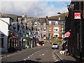
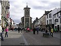
Main Street, Keswick
Main Street at the junction with Bank Street.
Main Street is the route of the Cumbria Way long distance path, northbound walkers continue straight ahead along Main Street through the pedestrianised market place (next photograph Image).
The stone built building on the left is the Town Hall and formerly housed Keswick Registration Office on the ground floor. The building on the left beyond Bank Street, now an outdoor store, was Keswick Post Office. There is an Ordnance Survey flush bracket benchmark on the corner of the building (photograph Image).
Image: © Adrian Taylor
Taken: 10 Sep 2022
0.01 miles
5
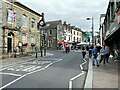
Main Street, Keswick
Looking south-east in the direction of Moot Hall
Image: © Kenneth Allen
Taken: 7 Oct 2009
0.01 miles
6
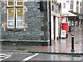
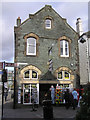
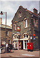
Corner of Keswick Post Office
Keswick Post Office is situated at the junction of Main Street and Bank Street. South east of this junction Main Street, leading into the market place, is pedestrianised.
There is an Ordnance Survey flush bracket benchmark on a stone quoin at the corner of the Post Office, facing onto Bank Street (detail photograph Image).
Main Street is the route of The Cumbria Way long distance path from Ulverston to Carlisle.
Image: © Adrian Taylor
Taken: 13 Mar 2008
0.01 miles
7
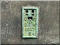
Benchmark, Keswick, Post Office
Detail of the Ordnance Survey flush bracket benchmark on the north west corner of the former Keswick Post Office at the junction of Main Street and Bank Street. The flush bracket, benchmark number S0207 marks a height of 81.2935m above sea level (Ordnance Datum Newlyn), last levelled in 1969 and verified in 1970 (location photograph Image).
This benchmark is adjacent to The Cumbria Way long distance trail.
Image: © Adrian Taylor
Taken: 10 Sep 2022
0.01 miles
8
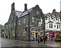
Keswick Post Office (1891)
Architect: J. Wood
Image: © Jim Osley
Taken: 27 Jun 2013
0.01 miles
9
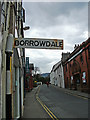
Signpost to Borrowdale
An easily-missed old signpost in a quiet corner of Keswick pointing travellers into Borrowdale down a side street off the A5271 towards the B5289, Heads Road.
Image: © michael ely
Taken: 26 Mar 2011
0.01 miles
10
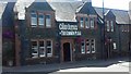
The Chief Justice of The Common Pleas
A Wetherspoons public house in Keswick
Image: © Colin Kinnear
Taken: 3 Jul 2018
0.01 miles