IMAGES TAKEN NEAR TO
Fisher Place, KESWICK, CA12 4TW
Introduction
This page details the photographs taken nearby to Fisher Place, CA12 4TW by members of the Geograph project.
The Geograph project started in 2005 with the aim of publishing, organising and preserving representative images for every square kilometre of Great Britain, Ireland and the Isle of Man.

There are currently over 7.5m images from over14,400 individuals and you can help contribute to the project by visiting https://www.geograph.org.uk
Image Map
Images are licensed for reuse under creativecommons.org/licenses/by-sa/2.0
Notes
- Clicking on the map will re-center to the selected point.
- The higher the marker number, the further away the image location is from the centre of the postcode.
Image Listing (14 Images Found)
Images are licensed for reuse under creativecommons.org/licenses/by-sa/2.0
Image
Details
Distance
2
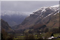
High Fells
Looking north from Thirlmere towards High Fells, the western edge of Matterdale Common.
Image: © Craig Allan
Taken: 25 Mar 2008
0.06 miles
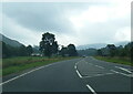
3
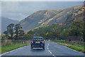
St John's Castlerigg and Wythburn : A591
Looking along the A591.
Image: © Lewis Clarke
Taken: 26 Sep 2019
0.08 miles
4
Above the Fall
Looking towards Great How from Fisherplace Gill
Image: © Michael Graham
Taken: 28 Dec 2008
0.18 miles
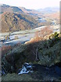
5
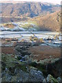
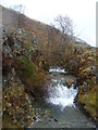
Fisherplace Gill
Makes an interesting ravine as it nears the valley. Thirlmere and Raven Crag in shot.
Image: © Michael Graham
Taken: 28 Dec 2008
0.19 miles
6
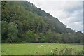
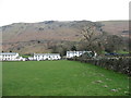
St John's Castlerigg and Wythburn : Grassy Field
Looking across a grassy field.
Image: © Lewis Clarke
Taken: 26 Sep 2019
0.19 miles
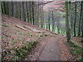
9
Fisherplace Gill
From the footbridge on the public footpath.
Image: © Michael Graham
Taken: 21 Apr 2013
0.20 miles
10
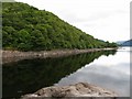
Thirlmere
This part of the lake is situated in the far north western corner of the grid square and was taken from the upper left adjoining grid at HMS Pumphouse.
Image: © Pam Brophy
Taken: 11 Jul 2004
0.21 miles