IMAGES TAKEN NEAR TO
Thirlmere, KESWICK, CA12 4TH
Introduction
This page details the photographs taken nearby to CA12 4TH by members of the Geograph project.
The Geograph project started in 2005 with the aim of publishing, organising and preserving representative images for every square kilometre of Great Britain, Ireland and the Isle of Man.

There are currently over 7.5m images from over14,400 individuals and you can help contribute to the project by visiting https://www.geograph.org.uk
Image Map
Images are licensed for reuse under creativecommons.org/licenses/by-sa/2.0
Notes
- Clicking on the map will re-center to the selected point.
- The higher the marker number, the further away the image location is from the centre of the postcode.
Image Listing (35 Images Found)
Images are licensed for reuse under creativecommons.org/licenses/by-sa/2.0
Image
Details
Distance
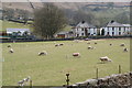
1
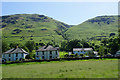
Legburthwaite
A collection of houses and farms below Stanah Gill. The gill is a deep gash in the hillside behind.
Image: © Bill Boaden
Taken: 17 Jun 2017
0.02 miles
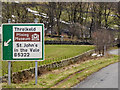
2
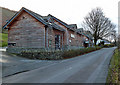
The Lodge in the Vale
I spent a couple of nights at this modern lodge accommodation just off the A591 between Keswick and Grasmere.
Image: © Walter Baxter
Taken: 19 Nov 2014
0.02 miles
3
The Lodge in the vale
This modern lodge accommodation is just off the A591 between Keswick and Grasmere.
Image: © Walter Baxter
Taken: 10 Feb 2015
0.02 miles
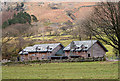
4
Former Youth Hostel, Legburthwaite
The former youth hostel closed in 2001. In April 2006 plans to demolish the building and to rebuild in stone and slate were refused Lake District planners. The Parish Council objected to the plans on the grounds the new 19 bed hostel "would be visually intrusive, there is no local need for the development, and on road safety issues". http://www.cwherald.com/archive/archive/hostel-%26%238220%3bwould-be-harmful-to-intimate-character-of-area%26%238221%3b-20060422230983.htm
Image: © Mick Garratt
Taken: 29 Dec 2007
0.02 miles
5
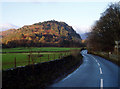
High Rigg from Legburthwaite
The B5322 to Threlkeld runs along this side of the long low ridge of High Rigg; the A591 to Keswick is on the other side.
Image: © David Gruar
Taken: 26 Nov 2005
0.03 miles
7
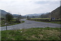
Where the B5322 joins the A591
Looking south with Thirlmere just behind the hill on the right.
Image: © Bill Boaden
Taken: 24 Apr 2010
0.06 miles
8
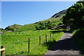
Path up to Sticks Pass
The path here uses a track which gives access to a farm at Stanah.
Image: © Bill Boaden
Taken: 17 Jun 2017
0.07 miles
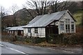
10
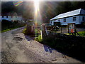
Legburthwaite village hall
Legburthwaite village hall by Stanah Lane
Image: © Shaun Ferguson
Taken: 3 Sep 2010
0.08 miles