IMAGES TAKEN NEAR TO
KESWICK, CA12 4RN
Introduction
This page details the photographs taken nearby to CA12 4RN by members of the Geograph project.
The Geograph project started in 2005 with the aim of publishing, organising and preserving representative images for every square kilometre of Great Britain, Ireland and the Isle of Man.

There are currently over 7.5m images from over14,400 individuals and you can help contribute to the project by visiting https://www.geograph.org.uk
Image Map
Images are licensed for reuse under creativecommons.org/licenses/by-sa/2.0
Notes
- Clicking on the map will re-center to the selected point.
- The higher the marker number, the further away the image location is from the centre of the postcode.
Image Listing (55 Images Found)
Images are licensed for reuse under creativecommons.org/licenses/by-sa/2.0
Image
Details
Distance
2
View Towards Blencathra
Seen from the road leading to the Castlerigg stone circle.
Image: © Peter Trimming
Taken: 6 Jul 2015
0.05 miles
3
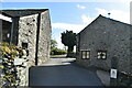
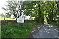
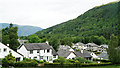
Welcome to Keswick
Welcome to Keswick as lane from Castlerigg stone circle heads down past High Fieldside
Image: © Shaun Ferguson
Taken: 27 May 2009
0.06 miles
4
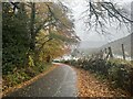
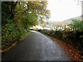
The Road to Castlerigg Stone Circle above Keswick
There was heavy rain on this dull November morning but the road still looked pretty with lots of fallen autumn leaves. At the top of this steep road lies the ancient stone circle. On this very wet morning there were no other visitors up there except the two photographers who had braved the weather !!
Image: © RKL
Taken: 15 Nov 2022
0.07 miles
7
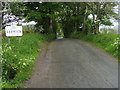
Country road east of Keswick
Looking along a damp country road east of Keswick.
Image: © Graham Robson
Taken: 5 Nov 2013
0.07 miles
8
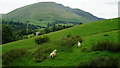
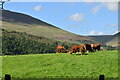
Pasture, Castlerigg
A view across the Greta valley and the eastern shoulder of Latrigg with Lonscale Fell in the background.
Image: © Andrew Smith
Taken: 4 Apr 2015
0.11 miles
9
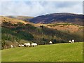
View Towards Brigham
Seen from the road leading to the Castlerigg stone circle.
Image: © Peter Trimming
Taken: 6 Jul 2015
0.13 miles
10
Keswick : Grassy Field
A grassy field between the A591 and the A66.
Image: © Lewis Clarke
Taken: 26 Sep 2019
0.13 miles