IMAGES TAKEN NEAR TO
Bassenthwaite, KESWICK, CA12 4QG
Introduction
This page details the photographs taken nearby to CA12 4QG by members of the Geograph project.
The Geograph project started in 2005 with the aim of publishing, organising and preserving representative images for every square kilometre of Great Britain, Ireland and the Isle of Man.

There are currently over 7.5m images from over14,400 individuals and you can help contribute to the project by visiting https://www.geograph.org.uk
Image Map
Images are licensed for reuse under creativecommons.org/licenses/by-sa/2.0
Notes
- Clicking on the map will re-center to the selected point.
- The higher the marker number, the further away the image location is from the centre of the postcode.
Image Listing (6 Images Found)
Images are licensed for reuse under creativecommons.org/licenses/by-sa/2.0
Image
Details
Distance
1
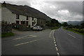
High Side
Road junction at High Side between a lane and the A591 road to Keswick. Ullock Pike can be seen in the background on the left.
Image: © Philip Halling
Taken: 24 Aug 2008
0.19 miles
2
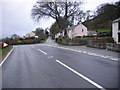
Road Junction at High Side.
Bend in the road makes this a tricky junction.
Image: © John Holmes
Taken: 3 Dec 2005
0.22 miles
3
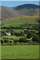
High Side and Skiddaw
High Side and Skiddaw viewed from the lane from Bassenthwaite to Scarness.
Image: © Philip Halling
Taken: 24 Aug 2008
0.22 miles
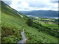
4
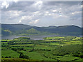
Descending to Ravenstone Hotel
Bassenthwaite Lake in the background
Image: © Gerald Davison
Taken: 24 May 2008
0.22 miles
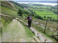
5
Descending Ullock Pike
Looking towards Bassentwaite Lake
Image: © Michael Graham
Taken: 14 Jul 2012
0.23 miles