IMAGES TAKEN NEAR TO
Underskiddaw, KESWICK, CA12 4PH
Introduction
This page details the photographs taken nearby to CA12 4PH by members of the Geograph project.
The Geograph project started in 2005 with the aim of publishing, organising and preserving representative images for every square kilometre of Great Britain, Ireland and the Isle of Man.

There are currently over 7.5m images from over14,400 individuals and you can help contribute to the project by visiting https://www.geograph.org.uk
Image Map
Images are licensed for reuse under creativecommons.org/licenses/by-sa/2.0
Notes
- Clicking on the map will re-center to the selected point.
- The higher the marker number, the further away the image location is from the centre of the postcode.
Image Listing (26 Images Found)
Images are licensed for reuse under creativecommons.org/licenses/by-sa/2.0
Image
Details
Distance
2
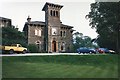
Underscar Manor
A Grade II listed building, which was a hotel at the time the photograph was taken [https://en.wikipedia.org/wiki/Underscar_Manor].
Image: © Richard Sutcliffe
Taken: Unknown
0.03 miles
3
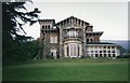
Underscar Manor
A Grade II listed building, which was a hotel at the time the photograph was taken [https://en.wikipedia.org/wiki/Underscar_Manor].
Image: © Richard Sutcliffe
Taken: Unknown
0.04 miles
7
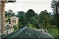
View from a bedroom, Underscar Manor
A Grade II listed building, which was a hotel at the time the photograph was taken [https://en.wikipedia.org/wiki/Underscar_Manor].
Image: © Richard Sutcliffe
Taken: Unknown
0.05 miles
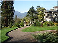
9
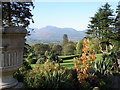
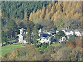
Underscar Manor Hotel - gardens and view to the south-west
Image: © Ian Hawfinch
Taken: 27 Oct 2005
0.06 miles
10
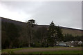
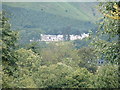
![The descent from Latrigg [10]](https://s0.geograph.org.uk/geophotos/06/21/38/6213832_5a6b5d7c_120x120.jpg)
The descent from Latrigg [10]
Seen from the bridleway, across a replanted area and Bruntholm Wood, is an area of woodland that has recently been felled. The roofs of the Underscar Manor Hotel can be glimpsed just below. The bridleway is part of the long distance Cumbria Way which runs 70 miles (112 km) from Carlisle to Ulverston.
Image: © Michael Dibb
Taken: 20 Jun 2019
0.06 miles