IMAGES TAKEN NEAR TO
Thrushwood, KESWICK, CA12 4PG
Introduction
This page details the photographs taken nearby to CA12 4PG by members of the Geograph project.
The Geograph project started in 2005 with the aim of publishing, organising and preserving representative images for every square kilometre of Great Britain, Ireland and the Isle of Man.

There are currently over 7.5m images from over14,400 individuals and you can help contribute to the project by visiting https://www.geograph.org.uk
Image Map
Images are licensed for reuse under creativecommons.org/licenses/by-sa/2.0
Notes
- Clicking on the map will re-center to the selected point.
- The higher the marker number, the further away the image location is from the centre of the postcode.
Image Listing (12 Images Found)
Images are licensed for reuse under creativecommons.org/licenses/by-sa/2.0
Image
Details
Distance
1
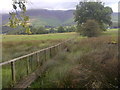
Walkway near Thrushwood
On the footpath to Ormathwaite.
Image: © Mick Garratt
Taken: 15 Jul 2014
0.05 miles
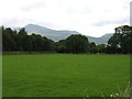
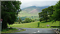
2
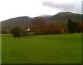
Field near Thrushwood
The walkers are on the footpath from Great Crosthwaite to Thrushwood. Snow covered Skiddaw in the background.
Image: © Adrian Taylor
Taken: 19 Nov 2006
0.12 miles
3
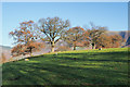
Field with four trees
The field is just north of the roundabout close to Keswick where the A66 and A591 cross. The trees conceal peaks of the Skiddaw range which rise behind them.
Image: © Trevor Littlewood
Taken: 17 Nov 2018
0.12 miles
4
Pipeline construction near Thrushwood
The new pipeline is part of United Utilities' ongoing project to lay a pipeline from Thirlmere to West Cumbria to replace the supply from Ennerdale. The project costing £300 million started in 2017 and is due for completion in 2022 https://keswickreminder.co.uk/2020/09/21/farmers-condemn-300m-thirlmere-pipeline-by-united-utilities-as-a-shambles/
Image: © Stephen Craven
Taken: 18 Sep 2020
0.13 miles
6

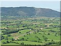
Towards Coledale
Looking towards the fells above Coledale from the slopes of Latrigg.
Image: © Ian Capper
Taken: 28 Sep 2018
0.17 miles
7
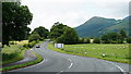
View Towards Dodd
Seen from the A591. Dodd Wood covers the lower slopes of Dodd.
Image: © Peter Trimming
Taken: 4 Jul 2015
0.20 miles
8
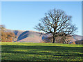
Field with lone tree
The field is just north of the roundabout close to Keswick where the A66 and A591 cross. The central hill spur is part of the Skiddaw massif; it rises to a feature named on OS maps as Jenkin Hill which has no individual high point of its own.
Image: © Trevor Littlewood
Taken: 17 Nov 2018
0.20 miles
9
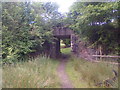
Footbridge under the Old Cockermouth, Keswick and Penrith Railway
Image: © Mick Garratt
Taken: 15 Jul 2014
0.20 miles
10
View Towards Skiddaw
Seen from the A591.
Image: © Peter Trimming
Taken: 4 Jul 2015
0.21 miles