IMAGES TAKEN NEAR TO
Underskiddaw, KESWICK, CA12 4PF
Introduction
This page details the photographs taken nearby to CA12 4PF by members of the Geograph project.
The Geograph project started in 2005 with the aim of publishing, organising and preserving representative images for every square kilometre of Great Britain, Ireland and the Isle of Man.

There are currently over 7.5m images from over14,400 individuals and you can help contribute to the project by visiting https://www.geograph.org.uk
Image Map
Images are licensed for reuse under creativecommons.org/licenses/by-sa/2.0
Notes
- Clicking on the map will re-center to the selected point.
- The higher the marker number, the further away the image location is from the centre of the postcode.
Image Listing (33 Images Found)
Images are licensed for reuse under creativecommons.org/licenses/by-sa/2.0
Image
Details
Distance
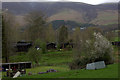
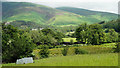
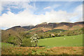
2
Field with lone tree
The field is just north of the roundabout close to Keswick where the A66 and A591 cross. The central hill spur is part of the Skiddaw massif; it rises to a feature named on OS maps as Jenkin Hill which has no individual high point of its own.
Image: © Trevor Littlewood
Taken: 17 Nov 2018
0.04 miles
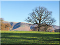
3
View Towards Skiddaw
Seen from the A591.
Image: © Peter Trimming
Taken: 4 Jul 2015
0.06 miles
4
View Towards Dodd
Seen from the A591. Dodd Wood covers the lower slopes of Dodd.
Image: © Peter Trimming
Taken: 4 Jul 2015
0.07 miles
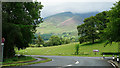
5
View From Keswick
Looking towards the lower slopes of Skiddaw, from the roundabout on the northern edge of Keswick.
Image: © Peter Trimming
Taken: 4 Jul 2015
0.07 miles
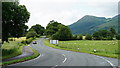
6
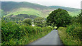
View Towards Skiddaw
This, the old road, links all the hamlets located at the base of Skiddaw.
Image: © Peter Trimming
Taken: 4 Jul 2015
0.10 miles
7
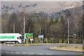
A66 outside Keswick
The large roundabout at the junction of the A66, A591 and A5271 just to the north of Keswick.
Image: © David Dixon
Taken: 15 Feb 2013
0.11 miles
8
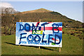
It's general election time again
There are several of these Conservative Party general election posters on either side of the A66 to the east of Keswick and most have been paint-sprayed with this message, obviously by non-Tory supporters. Latrigg is the fell in the background. This is how this poster would normally look Image
Image: © Walter Baxter
Taken: 16 Apr 2010
0.11 miles
9
Pasture near Keswick
Lowland north of Keswick with the higher fells of Lonscale and Skiddaw shrouded in cloud beyond.
Image: © Helen Wilkinson
Taken: 30 Apr 2009
0.11 miles
10
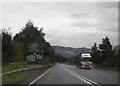
Approaching Crosthwaite Roundabout
On a wet A66.
Image: © Peter Bond
Taken: 19 Aug 2012
0.13 miles