IMAGES TAKEN NEAR TO
The Forge, KESWICK, CA12 4NX
Introduction
This page details the photographs taken nearby to The Forge, CA12 4NX by members of the Geograph project.
The Geograph project started in 2005 with the aim of publishing, organising and preserving representative images for every square kilometre of Great Britain, Ireland and the Isle of Man.

There are currently over 7.5m images from over14,400 individuals and you can help contribute to the project by visiting https://www.geograph.org.uk
Image Map
Images are licensed for reuse under creativecommons.org/licenses/by-sa/2.0
Notes
- Clicking on the map will re-center to the selected point.
- The higher the marker number, the further away the image location is from the centre of the postcode.
Image Listing (132 Images Found)
Images are licensed for reuse under creativecommons.org/licenses/by-sa/2.0
Image
Details
Distance
1
![Along the former railway [12]](https://s3.geograph.org.uk/geophotos/06/21/21/6212151_880fd683_120x120.jpg)
Along the former railway [12]
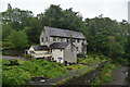
Brigham Forge Cottages seen from the path created on the trackbed of the dismantled Cockermouth, Keswick and Penrith Railway.
The cottages are early 19th century in a mixture of styles and sizes. Listed, grade II, with details at: https://historicengland.org.uk/listing/the-list/list-entry/1144663
A four mile long footpath was created by the Lake District National Park Authority between Threlkeld and Keswick though the Greta Gorge. Three bridges on the footpath were damaged or destroyed in the winter 2015 floods and are still (in 2019) in the process of being repaired.
The Cockermouth, Keswick and Penrith Railway was 31½ miles long with eight intermediate stations and opened in 1864. The section from Keswick to Cockermouth was closed in 1966 leaving Keswick at the end of a single line branch from Penrith which survived until 6th March, 1972.
Image: © Michael Dibb
Taken: 20 Jun 2019
0.00 miles
2
![Along the former railway [11]](https://s2.geograph.org.uk/geophotos/06/21/21/6212150_7fead9bb_120x120.jpg)
Along the former railway [11]
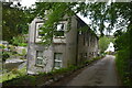
Forge Bridge seen from the path created on the trackbed of the dismantled Cockermouth, Keswick and Penrith Railway.
The bridge is dated 1817 and carries a narrow roadway over the River Greta. Listed, grade II, with details at: https://historicengland.org.uk/listing/the-list/list-entry/1144702
A four mile long footpath was created by the Lake District National Park Authority between Threlkeld and Keswick though the Greta Gorge. Three bridges on the footpath were damaged or destroyed in the winter 2015 floods and are still (in 2019) in the process of being repaired.
The Cockermouth, Keswick and Penrith Railway was 31½ miles long with eight intermediate stations and opened in 1864. The section from Keswick to Cockermouth was closed in 1966 leaving Keswick at the end of a single line branch from Penrith which survived until 6th March, 1972.
Image: © Michael Dibb
Taken: 20 Jun 2019
0.02 miles
5
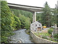
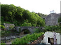
River Greta, Brigham, Keswick
The flyover is above the site of a former forge. The single storey building is a joinery.
Image: © Chris Allen
Taken: 20 Sep 2018
0.03 miles
6
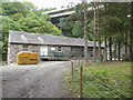
Stanley's Joinery, Brigham, Keswick
In a former industrial hamlet by the River Greta and overlooked by the A66 flyover.
Image: © Chris Allen
Taken: 20 Sep 2018
0.03 miles
7
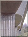
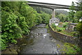
A66 road bridge over river Greta near Keswick
Voted best concrete structure of the century?
Image: © Tim Leete
Taken: 7 Feb 2004
0.03 miles
8
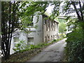
Forge Mill, Brigham, Keswick
Now apartments this was originally a water powered pencil mill and later a power station.
Image: © Chris Allen
Taken: 20 Sep 2018
0.03 miles