IMAGES TAKEN NEAR TO
Briar Rigg, KESWICK, CA12 4NN
Introduction
This page details the photographs taken nearby to Briar Rigg, CA12 4NN by members of the Geograph project.
The Geograph project started in 2005 with the aim of publishing, organising and preserving representative images for every square kilometre of Great Britain, Ireland and the Isle of Man.

There are currently over 7.5m images from over14,400 individuals and you can help contribute to the project by visiting https://www.geograph.org.uk
Image Map
Images are licensed for reuse under creativecommons.org/licenses/by-sa/2.0
Notes
- Clicking on the map will re-center to the selected point.
- The higher the marker number, the further away the image location is from the centre of the postcode.
Image Listing (180 Images Found)
Images are licensed for reuse under creativecommons.org/licenses/by-sa/2.0
Image
Details
Distance
1
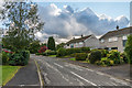
Briar Rigg
1960s housing off Brundholme Road.
Image: © Ian Capper
Taken: 23 Sep 2018
0.03 miles
2
Briar Rigg
Modern housing at Briar Rigg, seen from Brundholme Road.
Image: © Michael Dibb
Taken: 20 Jun 2019
0.03 miles
3
Briar Rigg
1960s housing on Brundholme Road.
Image: © Ian Capper
Taken: 23 Sep 2018
0.03 miles
4
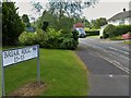
The Cumbria Way, Briar Rigg
The fenced path beside Briar Rigg comes to an abrupt end. Pedestrians are obliged to cross the road and continue along the pavement on the other side (next photograph Image).
Image: © Adrian Taylor
Taken: 15 May 2016
0.05 miles
5
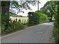
Path leaves the road
From the end of Spoonygreen Lane to this point of Brundholme Road there is a paved footpath. The path seen here has been created recently and begins just where the paved footpath ends. The new path allows walkers to avoid walking on the busy road. The path is part of the long distance Cumbria Way which runs 70 miles (112 km) from Carlisle to Ulverston.
Image: © Michael Dibb
Taken: 20 Jun 2019
0.05 miles
6
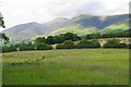
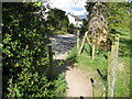
Sheep at Briar Rigg
Looking north from Brundholme Road, which is the edge of the built up area of Keswick. Skiddaw stands invitingly behind.
Image: © Bill Boaden
Taken: 22 Jun 2019
0.06 miles
7
Newish houses on Station Avenue, Keswick
Built on the route of the former Penrith - Keswick - Cockermouth - Workington railway line.
Image: © Christine Johnstone
Taken: 25 Mar 2018
0.06 miles
8
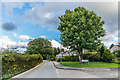
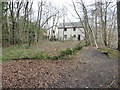
Briar Rigg, Keswick
Briar Rigg is a popular parking place and starting point for walkers wishing to climb Skiddaw. The Cumbria Way follows the road here to the end of Spoonygreen Lane (next photograph Image).
Briar Rigg is incorrectly named as Brundholme Road on some Ordnance Survey maps.
Image: © Adrian Taylor
Taken: 15 May 2016
0.06 miles
9
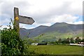
Signpost to Skiddaw
'Public Bridleway Skiddaw 4 miles' - the post at the foot of Spooney Green Lane points to the summit ridge.
Image: © Jim Barton
Taken: 18 Jun 2019
0.08 miles
10
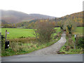
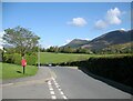
Junction of Spooney Green Lane and Brundholme Road, Keswick
The junction between Spoony Green Lane, heading into the distance, and Brundholme Road. The signpost is indicating a public bridleway in the direction of Latrigg and Skiddaw, and the track also forms part of the Cumbria Way long distance footpath.
Image: © Graham Robson
Taken: 7 Nov 2012
0.08 miles