IMAGES TAKEN NEAR TO
Station Road, KESWICK, CA12 4ND
Introduction
This page details the photographs taken nearby to Station Road, CA12 4ND by members of the Geograph project.
The Geograph project started in 2005 with the aim of publishing, organising and preserving representative images for every square kilometre of Great Britain, Ireland and the Isle of Man.

There are currently over 7.5m images from over14,400 individuals and you can help contribute to the project by visiting https://www.geograph.org.uk
Image Map
Images are licensed for reuse under creativecommons.org/licenses/by-sa/2.0
Notes
- Clicking on the map will re-center to the selected point.
- The higher the marker number, the further away the image location is from the centre of the postcode.
Image Listing (710 Images Found)
Images are licensed for reuse under creativecommons.org/licenses/by-sa/2.0
Image
Details
Distance
1

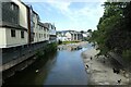
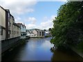
River Greta in Keswick
The River Greta, seen from the Station Road bridge over the river. Looking down stream at a full looking river after a period of heavy autumn rain.
Image: © Graham Robson
Taken: 3 Nov 2009
0.01 miles
2
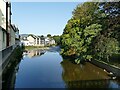
Downstream along the Greta
Looking down the river from Station Street.
Image: © DS Pugh
Taken: 19 Jul 2021
0.01 miles
3
River Greta downstream from Station Road, Keswick
The building on the left is the Youth Hostel.
Image: © Stephen Craven
Taken: 17 Sep 2020
0.02 miles
4
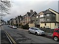
Station Road
Entrance to the Keswick YHA
Image: © James Emmans
Taken: 12 Dec 2018
0.02 miles
5
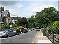
Station Road, Keswick
Station Road was constructed by the Cockermouth, Keswick and Penrith Railway Company to give direct access from Keswick town centre to the railway station. It is the route of The Cumbria Way long distance trail from Ulverston to Carlisle (next photograph Image).
Image: © Adrian Taylor
Taken: 19 Jun 2014
0.02 miles
6
The River Greta, Keswick
As viewed from the bridge on Station Road.
Image: © James T M Towill
Taken: 6 Aug 2016
0.02 miles
7
![Over the river [1]](https://s0.geograph.org.uk/geophotos/06/21/81/6218140_5424c89a_120x120.jpg)
Over the river [1]
The attractive bridge carries Station Road over the River Greta. Built in 1865 to connect the railway station with the town it comprises three 58 feet (17 metres) long arched cast iron ribs.
Image: © Michael Dibb
Taken: 20 Jun 2019
0.02 miles
8
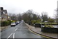
Station Road
Looking along Station Road from the junction with Victoria Street towards the river crossing.
Image: © DS Pugh
Taken: 26 Mar 2016
0.02 miles
9
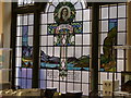
Stained glass in the Co-op
Samuel Taylor Coleridge
Image: © Ian Cardinal
Taken: 23 Feb 2011
0.02 miles
10
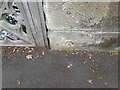
Ordnance Survey Cut Mark
This OS cut mark can be found on the SE parapet of the River Greta Bridge, Station Road. It marks a point 85.709m above mean sea level.
Image: © Adrian Dust
Taken: 14 Sep 2022
0.02 miles