IMAGES TAKEN NEAR TO
Chestnut Hill, KESWICK, CA12 4LS
Introduction
This page details the photographs taken nearby to Chestnut Hill, CA12 4LS by members of the Geograph project.
The Geograph project started in 2005 with the aim of publishing, organising and preserving representative images for every square kilometre of Great Britain, Ireland and the Isle of Man.

There are currently over 7.5m images from over14,400 individuals and you can help contribute to the project by visiting https://www.geograph.org.uk
Image Map
Images are licensed for reuse under creativecommons.org/licenses/by-sa/2.0
Notes
- Clicking on the map will re-center to the selected point.
- The higher the marker number, the further away the image location is from the centre of the postcode.
Image Listing (61 Images Found)
Images are licensed for reuse under creativecommons.org/licenses/by-sa/2.0
Image
Details
Distance
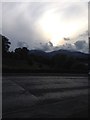
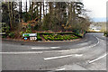
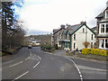
1
Barf, Woodleigh and Sunny Bank
Housing on Chestnut Hill.
Image: © Ian Capper
Taken: 24 Sep 2018
0.02 miles
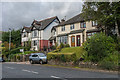
2
The Cottage
Cottage on Chestnut Hill, built around 1800.
Image: © Ian Capper
Taken: 24 Sep 2018
0.07 miles
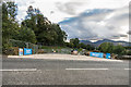
3
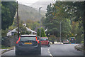
Keswick : Chestnut Hill A591
Heading into Keswick.
Image: © Lewis Clarke
Taken: 26 Sep 2019
0.08 miles
4
Keswick, Chestnut Hill
Topiary welcoming visitors to Keswick.
Image: © David Dixon
Taken: 15 Feb 2013
0.10 miles
5
West Cumbria Water Supplies Project
Access Point 08 on Chestnut Hill to United Utilities' West Cumbria Water Supplies Project, laying a new pipeline which will result in West Cumbria being supplied with water from Thirlmere in place of Ennerdale Water, the licence for abstraction from which will expire in 2022.
Image: © Ian Capper
Taken: 24 Sep 2018
0.10 miles
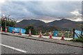
6
West Cumbria Water Supplies Project
Access Point 08 on Chestnut Hill to United Utilities' West Cumbria Water Supplies Project, laying a new pipeline which will result in West Cumbria being supplied with water from Thirlmere in place of Ennerdale Water, the licence for abstraction from which will expire in 2022.
Image: © Ian Capper
Taken: 24 Sep 2018
0.10 miles
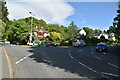
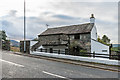
8
Keswick, Penrith Road
The hill into Keswick.
Image: © David Dixon
Taken: 15 Feb 2013
0.11 miles
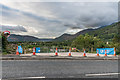
9
West Cumbria Water Supplies Project
Access Point 09 on Penrith Road to United Utilities' West Cumbria Water Supplies Project, laying a new pipeline which will result in West Cumbria being supplied with water from Thirlmere in place of Ennerdale Water, the licence for abstraction from which will expire in 2022.
Image: © Ian Capper
Taken: 24 Sep 2018
0.12 miles