IMAGES TAKEN NEAR TO
Browfoot, KESWICK, CA12 4LQ
Introduction
This page details the photographs taken nearby to Browfoot, CA12 4LQ by members of the Geograph project.
The Geograph project started in 2005 with the aim of publishing, organising and preserving representative images for every square kilometre of Great Britain, Ireland and the Isle of Man.

There are currently over 7.5m images from over14,400 individuals and you can help contribute to the project by visiting https://www.geograph.org.uk
Image Map
Images are licensed for reuse under creativecommons.org/licenses/by-sa/2.0
Notes
- Clicking on the map will re-center to the selected point.
- The higher the marker number, the further away the image location is from the centre of the postcode.
Image Listing (117 Images Found)
Images are licensed for reuse under creativecommons.org/licenses/by-sa/2.0
Image
Details
Distance
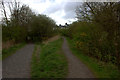
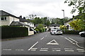
3
The Cycleway to Threlkeld
There are plans to reopen the line from Penrith to Keswick. The Cockermouth, Keswick and Penrith Railway (CK&PR) was incorporated by Act of Parliament on 1 August 1861, for a line connecting the town of Cockermouth with the London and North Western Railway (LNWR) West Coast Main Line at Penrith.
Image: © Nigel Homer
Taken: 12 Feb 2006
0.04 miles
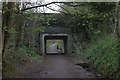
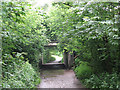
5
![Along the former railway [8]](https://s2.geograph.org.uk/geophotos/06/21/21/6212134_d7335cd1_120x120.jpg)
Along the former railway [8]
A section of the path created on the trackbed of the dismantled Cockermouth, Keswick and Penrith Railway. The main path is to the left, the path on the right leads up to Penrith Road.
A four mile long footpath was created by the Lake District National Park Authority between Threlkeld and Keswick though the Greta Gorge. Three bridges on the footpath were damaged or destroyed in the winter 2015 floods and are still (in 2019) in the process of being repaired.
The Cockermouth, Keswick and Penrith Railway was 31½ miles long with eight intermediate stations and opened in 1864. The section from Keswick to Cockermouth was closed in 1966 leaving Keswick at the end of a single line branch from Penrith which survived until 6th March, 1972.
Image: © Michael Dibb
Taken: 20 Jun 2019
0.04 miles
6
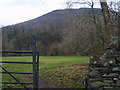
Under Latrigg
From the lane to the Forge and Builders Merchants in Keswick
Image: © Michael Graham
Taken: 14 Jan 2009
0.04 miles
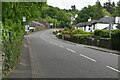
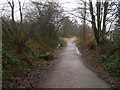
9
Road bridge over the railway path
The concrete road bridge carries Penrith Road over the old railway (now a cycle track), which was muddy after several wet days.
Image: © Stephen Craven
Taken: 21 Jun 2011
0.06 miles