IMAGES TAKEN NEAR TO
Penrith Road, KESWICK, CA12 4JR
Introduction
This page details the photographs taken nearby to Penrith Road, CA12 4JR by members of the Geograph project.
The Geograph project started in 2005 with the aim of publishing, organising and preserving representative images for every square kilometre of Great Britain, Ireland and the Isle of Man.

There are currently over 7.5m images from over14,400 individuals and you can help contribute to the project by visiting https://www.geograph.org.uk
Image Map
Images are licensed for reuse under creativecommons.org/licenses/by-sa/2.0
Notes
- Clicking on the map will re-center to the selected point.
- The higher the marker number, the further away the image location is from the centre of the postcode.
Image Listing (143 Images Found)
Images are licensed for reuse under creativecommons.org/licenses/by-sa/2.0
Image
Details
Distance
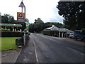
1
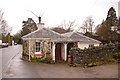
Toll Bar Cottage
Old toll cottage on the road into Keswick from the east. This would have been the original route from Penrith, although Keswick itself is now bypassed by the A66.
Image: © Ian Capper
Taken: 11 Apr 2008
0.00 miles
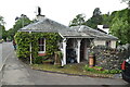
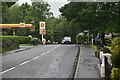
3
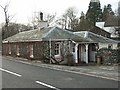
Tollhouse by the A5271, Penrith Road, Brigham
Tollhouse by the A5271, in the parish of Keswick (Allerdale District), Toll Bar Cottage, Penrith Road, Brigham, CA12 4JR.
Lake District National Park HER.
https://www.heritagegateway.org.uk/Gateway/Results_Single.aspx?uid=2886341&resourceID=801
To be surveyed
Milestone Society National ID: CB.KES01
Image: © Milestone Society
Taken: Unknown
0.00 miles
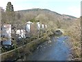
4
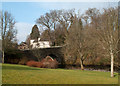
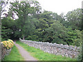
Calvert's Bridge, Keswick
Calvert's Bridge crosses the River Greta east of the town centre of Keswick; it's a grade II listed building and is seen here from Penrith Road across a small park.
Image: © Trevor Littlewood
Taken: 7 Mar 2011
0.01 miles
7
River Greta, Calvert's Bridge and Latrigg
Image: © Anthony Foster
Taken: 19 Mar 2015
0.02 miles
8
![Along the former railway [5]](https://s1.geograph.org.uk/geophotos/06/21/21/6212125_129d2498_120x120.jpg)
Along the former railway [5]
A view of the River Greta looking upstream from the bridge carrying the path created on the trackbed of the dismantled Cockermouth, Keswick and Penrith Railway.
The bridge seen in the distance is Calvert's Bridge, possibly built in the 19th century and listed, grade II, with details at: https://historicengland.org.uk/listing/the-list/list-entry/1137418
A four mile long footpath was created by the Lake District National Park Authority between Threlkeld and Keswick though the Greta Gorge. Three bridges on the footpath were damaged or destroyed in the winter 2015 floods and are still (in 2019) in the process of being repaired.
The Cockermouth, Keswick and Penrith Railway was 31½ miles long with eight intermediate stations and opened in 1864. The section from Keswick to Cockermouth was closed in 1966 leaving Keswick at the end of a single line branch from Penrith which survived until 6th March, 1972.
Image: © Michael Dibb
Taken: 20 Jun 2019
0.02 miles
9
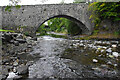
Calvert's Bridge
A narrow road bridge (closed to vehicles) across the River Greta. Looking downstream. Grade II listed - https://historicengland.org.uk/listing/the-list/list-entry/1137418
The former railway bridge is in the background.
Image: © Ian Taylor
Taken: 25 Sep 2021
0.02 miles
10
On top of Calvert's Bridge
This footbridge is so wide, with slate parapets like field walls, that one could easily walk across it without realising one was on a bridge. The bridge is grade 2 listed. For a side view, see Image
Image: © Stephen Craven
Taken: 21 Jun 2011
0.02 miles