IMAGES TAKEN NEAR TO
Trinity Way, KESWICK, CA12 4HZ
Introduction
This page details the photographs taken nearby to Trinity Way, CA12 4HZ by members of the Geograph project.
The Geograph project started in 2005 with the aim of publishing, organising and preserving representative images for every square kilometre of Great Britain, Ireland and the Isle of Man.

There are currently over 7.5m images from over14,400 individuals and you can help contribute to the project by visiting https://www.geograph.org.uk
Image Map
Images are licensed for reuse under creativecommons.org/licenses/by-sa/2.0
Notes
- Clicking on the map will re-center to the selected point.
- The higher the marker number, the further away the image location is from the centre of the postcode.
Image Listing (106 Images Found)
Images are licensed for reuse under creativecommons.org/licenses/by-sa/2.0
Image
Details
Distance
1
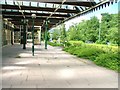
Former Keswick Railway Station
Now owned by an hotel and well maintained but sadly underused. Situated alongside the Keswick Railway Cyclepath it really has potential.
Image: © Mick Garratt
Taken: 16 Jul 2005
0.06 miles
2
Footpath to school
A view from the cycle path along the former railway line outside Keswick, looking down along a footpath that leads from the main Penrith Road to a school.
Image: © Stephen Craven
Taken: 21 Jun 2011
0.12 miles
3
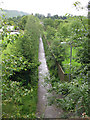
![Along the former railway [7]](https://s3.geograph.org.uk/geophotos/06/21/21/6212131_06e3ed92_120x120.jpg)
Along the former railway [7]
A section of the path created on the trackbed of the dismantled Cockermouth, Keswick and Penrith Railway.
A four mile long footpath was created by the Lake District National Park Authority between Threlkeld and Keswick though the Greta Gorge. Three bridges on the footpath were damaged or destroyed in the winter 2015 floods and are still (in 2019) in the process of being repaired.
The Cockermouth, Keswick and Penrith Railway was 31½ miles long with eight intermediate stations and opened in 1864. The section from Keswick to Cockermouth was closed in 1966 leaving Keswick at the end of a single line branch from Penrith which survived until 6th March, 1972.
Image: © Michael Dibb
Taken: 20 Jun 2019
0.12 miles
4
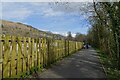
Fence along the former railway line
The course of the former Cockermouth, Keswick and Penrith Railway is now a cycle path between Keswick and Threlkeld. The route is part of National Cycle Network route 71 and was substantially reconstructed following substantial flood damage in December 2015 from Storm Desmond.
Image: © DS Pugh
Taken: 31 Mar 2024
0.14 miles
5
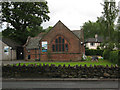
Superglaze: old church
One of several buildings on Penrith Road occupied by a glazing firm called Superglaze, this one looks like a former church (but I have not identified which denomination).
Image: © Stephen Craven
Taken: 21 Jun 2011
0.15 miles
6
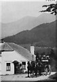
Tollhouse by the A591, Chestnut Hill, Keswick
Former Tollhouse by the A591, in the parish of Keswick (Allerdale District),
Toll Bar Cottage, Chestnut Hill junction with Manor Brow, CA12 4LT. More data at https://www.lakesguides.co.uk/html/lgaz/LK14643.htm
A recent view is Image
Grade II listed. 1327117 https://historicengland.org.uk/listing/the-list/list-entry/1327117
Milestone Society National ID: CB.KES02
Image: © the Estate of C Smith
Taken: 1 Jan 1900
0.15 miles
8
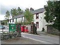
Low Brigham, Keswick
A short terrace of houses on the south side of Penrith Road,facing the former drill hall.
Image: © Christine Johnstone
Taken: 15 May 2015
0.15 miles
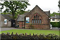
9
Keswick's former drill hall, south side
Once a World war One drill hall. Now home to both an outdoor activities hostel business and the Keswick Detachment of the Army Cadet Force.
Image: © Christine Johnstone
Taken: 15 May 2015
0.16 miles
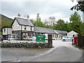
10
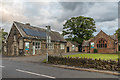
Former Brigham School
The former Brigham School on Penrith Road, with a date plaque on the building on the left of 1851. The building on the right was added in 1895. The school closed in the 1990s following the building of St Kentigern’s School in Trinity Way in 1993, now part of St Herbert's School. The buildings now house a double glazing firm.
Image: © Ian Capper
Taken: 24 Sep 2018
0.16 miles