IMAGES TAKEN NEAR TO
Shorley Lane, KESWICK, CA12 4HN
Introduction
This page details the photographs taken nearby to Shorley Lane, CA12 4HN by members of the Geograph project.
The Geograph project started in 2005 with the aim of publishing, organising and preserving representative images for every square kilometre of Great Britain, Ireland and the Isle of Man.

There are currently over 7.5m images from over14,400 individuals and you can help contribute to the project by visiting https://www.geograph.org.uk
Image Map
Images are licensed for reuse under creativecommons.org/licenses/by-sa/2.0
Notes
- Clicking on the map will re-center to the selected point.
- The higher the marker number, the further away the image location is from the centre of the postcode.
Image Listing (672 Images Found)
Images are licensed for reuse under creativecommons.org/licenses/by-sa/2.0
Image
Details
Distance
1
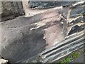
Ordnance Survey Cut Mark
This badly damaged OS cut mark can be found on No7 Blencathra Street. It marks a point 87.941m above mean sea level.
Image: © Adrian Dust
Taken: 14 Sep 2022
0.01 miles
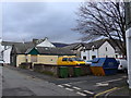
2
Junction of Southey Street and Blencathra Street
Image: © Basher Eyre
Taken: 17 Feb 2015
0.04 miles
4
Junction of Shorley Lane and Southey Street
Image: © Basher Eyre
Taken: 17 Feb 2015
0.04 miles
8
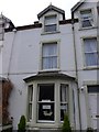
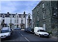
![Keswick buildings [10]](https://s0.geograph.org.uk/geophotos/06/21/70/6217092_bf697204_120x120.jpg)
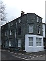
Keswick buildings [10]
This guest house in Penrith Road had some nice Dutch gables. Shame about the hideous dormer window.
Image: © Michael Dibb
Taken: 20 Jun 2019
0.04 miles
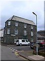
9
Southey Street, Keswick
Viewed from Blencathra Street.
Image: © Roger Cornfoot
Taken: 1 Apr 2007
0.04 miles