IMAGES TAKEN NEAR TO
Springs Road, KESWICK, CA12 4AN
Introduction
This page details the photographs taken nearby to Springs Road, CA12 4AN by members of the Geograph project.
The Geograph project started in 2005 with the aim of publishing, organising and preserving representative images for every square kilometre of Great Britain, Ireland and the Isle of Man.

There are currently over 7.5m images from over14,400 individuals and you can help contribute to the project by visiting https://www.geograph.org.uk
Image Map
Images are licensed for reuse under creativecommons.org/licenses/by-sa/2.0
Notes
- Clicking on the map will re-center to the selected point.
- The higher the marker number, the further away the image location is from the centre of the postcode.
Image Listing (29 Images Found)
Images are licensed for reuse under creativecommons.org/licenses/by-sa/2.0
Image
Details
Distance

4
Lakeland Park, Keswick
A housing development on the southern edge of the town.
Image: © David Purchase
Taken: 9 Nov 2013
0.09 miles
6
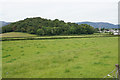
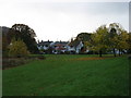
Fields by Castlehead
Keswick is to the right of Castlehead which is the small wooded hill. The spire of St John's Church is prominent.
Image: © Bill Boaden
Taken: 23 Jun 2019
0.14 miles
7
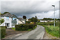
Springs Road
c1950s(?) housing (this section and that in the distance are shown as undeveloped on the 1938 1:2,500 map) on Springs Road on what was prior to development the access track to the 19th Century Springs Farm.
Image: © Ian Capper
Taken: 24 Sep 2018
0.14 miles
8
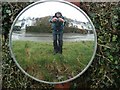
Round the bend
Useful to drivers these convex mirrors have other uses until they get vandalised.
Image: © Paul Glover
Taken: 8 Mar 2008
0.15 miles
9
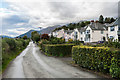
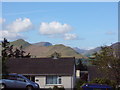
Springs Road
c1930s housing (or possibly later - this section is shown as undeveloped on the 1938 1:2,500 map) on Springs Road on what was prior to development the access track to the 19th Century Springs Farm. In the background is Skiddaw, the summit of which can just be seen above the houses.
Image: © Ian Capper
Taken: 24 Sep 2018
0.16 miles
