IMAGES TAKEN NEAR TO
Manor Park, KESWICK, CA12 4AB
Introduction
This page details the photographs taken nearby to Manor Park, CA12 4AB by members of the Geograph project.
The Geograph project started in 2005 with the aim of publishing, organising and preserving representative images for every square kilometre of Great Britain, Ireland and the Isle of Man.

There are currently over 7.5m images from over14,400 individuals and you can help contribute to the project by visiting https://www.geograph.org.uk
Image Map
Images are licensed for reuse under creativecommons.org/licenses/by-sa/2.0
Notes
- Clicking on the map will re-center to the selected point.
- The higher the marker number, the further away the image location is from the centre of the postcode.
Image Listing (201 Images Found)
Images are licensed for reuse under creativecommons.org/licenses/by-sa/2.0
Image
Details
Distance
1
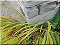
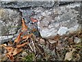
Ordnance Survey Cut Mark
This OS cut mark can be found on No15 Manor Park. It marks a point 89.584m above mean sea level.
Image: © Adrian Dust
Taken: 14 Sep 2022
0.01 miles
2
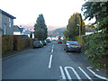
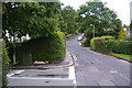
Manor Park, Keswick
Looking along Manor Park, Keswick, from its junction with Ambleside Road.
Image: © Graham Robson
Taken: 5 Nov 2012
0.05 miles
3
![The views from Latrigg [2]](https://s0.geograph.org.uk/geophotos/06/21/38/6213800_230ca1ea_120x120.jpg)
The views from Latrigg [2]
From the summit is this view of Keswick and Derwent Water.
Image: © Michael Dibb
Taken: 20 Jun 2019
0.06 miles
4
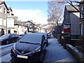
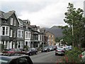
Eskin Street, Keswick
One of the many streets in Keswick where most properties are guesthouses.
Image: © Bryan Pready
Taken: 11 Mar 2013
0.07 miles
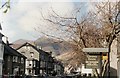
6
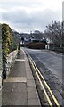
Ambleside Road, Keswick
It becomes Manor Brow when it goes up the hill. This is a useful secondary route into the town, and is a means of getting to Borrowdale without going through the town centre.
Image: © Bill Boaden
Taken: 28 May 2011
0.08 miles
7
Ordnance Survey Cut Mark
This OS cut mark can be found on the wall north side of Ambleside Road. It marks a point 99.075m above mean sea level.
Image: © Adrian Dust
Taken: 14 Sep 2022
0.08 miles
9
Eskin Street, Keswick
Guest houses abound in this street and its neighbourhood.
Image: © Lis Burke
Taken: 23 Sep 2008
0.11 miles
10
Ordnance Survey Cut Mark
This OS cut mark can be found on No24 Helvellyn Street. It marks a point 87.000m above mean sea level.
Image: © Adrian Dust
Taken: 14 Sep 2022
0.11 miles