IMAGES TAKEN NEAR TO
Plumpton, PENRITH, CA11 9NP
Introduction
This page details the photographs taken nearby to CA11 9NP by members of the Geograph project.
The Geograph project started in 2005 with the aim of publishing, organising and preserving representative images for every square kilometre of Great Britain, Ireland and the Isle of Man.

There are currently over 7.5m images from over14,400 individuals and you can help contribute to the project by visiting https://www.geograph.org.uk
Image Map
Images are licensed for reuse under creativecommons.org/licenses/by-sa/2.0
Notes
- Clicking on the map will re-center to the selected point.
- The higher the marker number, the further away the image location is from the centre of the postcode.
Image Listing (31 Images Found)
Images are licensed for reuse under creativecommons.org/licenses/by-sa/2.0
Image
Details
Distance
1

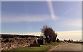
Grass field in front of Mounseybank
Image: © Roger Templeman
Taken: 10 Jan 2022
0.02 miles
3
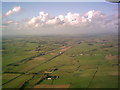
M6 and Solway to the north
Taken from a microlight aeroplane on a beautiful clear day
Image: © Les Hodgson
Taken: 18 Feb 2006
0.12 miles
4
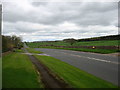
The A6 at Plumpton Head
Heading for Carlisle.
Image: © David Purchase
Taken: 28 Apr 2018
0.13 miles
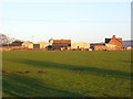
5
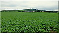
Fodder crop and Mounseybank
East of the A6.
Image: © Jonathan Billinger
Taken: 14 Aug 2013
0.14 miles
6
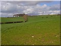
Pasture near Plumpton
Farmland east of the A6. The land to the west is, in contrast, arable at this point.
Image: © Andrew Smith
Taken: 24 Apr 2008
0.15 miles
7
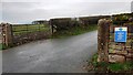
Entrance road to Mounsey Bank from east side of A6
Image: © Luke Shaw
Taken: 10 Jan 2022
0.15 miles

9

Edward VII GPO cable marker on east side of A6 west of Mounsey Bank
Image: © Luke Shaw
Taken: 10 Jan 2022
0.17 miles