IMAGES TAKEN NEAR TO
Raiselands Croft, PENRITH, CA11 9JH
Introduction
This page details the photographs taken nearby to Raiselands Croft, CA11 9JH by members of the Geograph project.
The Geograph project started in 2005 with the aim of publishing, organising and preserving representative images for every square kilometre of Great Britain, Ireland and the Isle of Man.

There are currently over 7.5m images from over14,400 individuals and you can help contribute to the project by visiting https://www.geograph.org.uk
Image Map
Images are licensed for reuse under creativecommons.org/licenses/by-sa/2.0
Notes
- Clicking on the map will re-center to the selected point.
- The higher the marker number, the further away the image location is from the centre of the postcode.
Image Listing (58 Images Found)
Images are licensed for reuse under creativecommons.org/licenses/by-sa/2.0
Image
Details
Distance
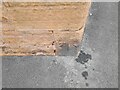
2
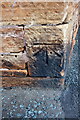
Benchmark on 'The White Ox'
Ordnance Survey cut mark benchmark described on the Bench Mark Database at http://www.bench-marks.org.uk/bm66918
Image: © Roger Templeman
Taken: 26 May 2015
0.04 miles
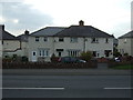
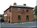
3
'The White Ox', Scotland Road
Formerly an Inn, then farmhouse, now offices. There is an OS benchmark Image on the near corner of the building, left hand face
Image: © Roger Templeman
Taken: 26 May 2015
0.04 miles
5
Ordnance Survey Cut Mark
This OS cut mark can be found on the White Ox Farm. It marks a point 160.255m above mean sea level.
Image: © Adrian Dust
Taken: 14 Sep 2022
0.04 miles
6
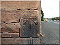
Benchmark, White Ox Farm
Detail of the Ordnance Survey cut benchmark on the south west corner of White Ox Farm house. The benchmark marks a height of 160.2547m above mean sea level (Ordnance Datum Newlyn) last verified in 1972 (location photograph Image).
Image: © Adrian Taylor
Taken: 6 Sep 2021
0.04 miles
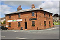
7
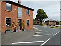
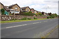
White Ox Farm, Penrith
At the junction of the A6 Scotland Road and Salkeld Road, the red sandstone building now in commercial use was once the farmhouse of White Ox Farm. On a stone quoin at the bottom of the corner of the building there is an Ordnance Survey cut benchmark (photograph Image).
Image: © Adrian Taylor
Taken: 6 Sep 2021
0.04 miles
9
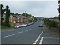
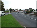
The A6, Scotland Road
There is an OS benchmark Image on the wall on the left hand side of the road, about 1.5m left of a no waiting sign
Image: © Roger Templeman
Taken: 26 May 2015
0.07 miles