IMAGES TAKEN NEAR TO
Haweswater Close, PENRITH, CA11 9BU
Introduction
This page details the photographs taken nearby to Haweswater Close, CA11 9BU by members of the Geograph project.
The Geograph project started in 2005 with the aim of publishing, organising and preserving representative images for every square kilometre of Great Britain, Ireland and the Isle of Man.

There are currently over 7.5m images from over14,400 individuals and you can help contribute to the project by visiting https://www.geograph.org.uk
Image Map
Images are licensed for reuse under creativecommons.org/licenses/by-sa/2.0
Notes
- Clicking on the map will re-center to the selected point.
- The higher the marker number, the further away the image location is from the centre of the postcode.
Image Listing (34 Images Found)
Images are licensed for reuse under creativecommons.org/licenses/by-sa/2.0
Image
Details
Distance


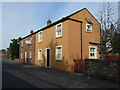
5
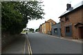
Norfolk Road in Castletown
Looking along Castletown on the western side of Penrith.
Image: © DS Pugh
Taken: 11 Jul 2020
0.10 miles
6
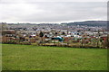
Allotments in Castletown
The view from Norfolk Road takes in a lot of the northern suburbs of Penrith. There is a small piece of public grassland in the foreground.
Image: © Bill Boaden
Taken: 5 Mar 2014
0.11 miles
7
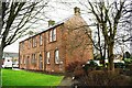
Cookson House off Newton Road
There is an Ordnance Survey benchmark Image on the far corner of the building, a former hospital converted to flats
Image: © Luke Shaw
Taken: 19 Apr 2020
0.11 miles
8
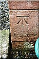
Benchmark on Cookson House
Ordnance Survey cut mark benchmark described on the Bench Mark Database at www.bench-marks.org.uk/bm102580
Image: © Luke Shaw
Taken: 19 Apr 2020
0.11 miles
10
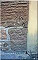
Benchmark on #2 Pleasant Wood
Ordnance Survey cut mark benchmark described on the Bench Mark Database at http://www.bench-marks.org.uk/bm67369
Image: © Roger Templeman
Taken: 26 May 2015
0.12 miles