IMAGES TAKEN NEAR TO
Paddock Row, Inglewood Road, CA11 8UX
Introduction
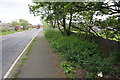
This page details the photographs taken nearby to Paddock Row, Inglewood Road, CA11 8UX by members of the Geograph project.
The Geograph project started in 2005 with the aim of publishing, organising and preserving representative images for every square kilometre of Great Britain, Ireland and the Isle of Man.

There are currently over 7.5m images from over14,400 individuals and you can help contribute to the project by visiting https://www.geograph.org.uk
Image Map
Images are licensed for reuse under creativecommons.org/licenses/by-sa/2.0
Notes
- Clicking on the map will re-center to the selected point.
- The higher the marker number, the further away the image location is from the centre of the postcode.
Image Listing (22 Images Found)
Images are licensed for reuse under creativecommons.org/licenses/by-sa/2.0
Image
Details
Distance
1
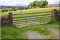
Gateway to field, Inglewood Road
There is an OS benchmark Image on the inside face of the right hand gatepost
Image: © Roger Templeman
Taken: 26 May 2015
0.01 miles
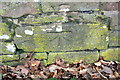
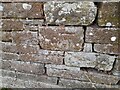
2
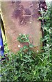
Benchmark on gatepost on SW side Inglewood Road
Ordnance Survey cut mark benchmark described on the Bench Mark Database at http://www.bench-marks.org.uk/bm56184
Image: © Roger Templeman
Taken: 26 May 2015
0.01 miles
3
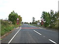
Entering Penrith
Heading south east on the A6.
Image: © JThomas
Taken: 10 Oct 2015
0.14 miles
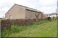
4

Benchmark on wall of caravan site, Inglewood Road
Ordnance Survey cut mark benchmark described on the Bench Mark Database at http://www.bench-marks.org.uk/bm66980
Image: © Roger Templeman
Taken: 26 May 2015
0.14 miles
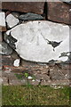
5
Wall beside Inglewood Road at Caravan Park near White Ox Farm
There is an OS benchmark Image on a stone in the wall near a piece of blue litter
Image: © Roger Templeman
Taken: 26 May 2015
0.15 miles
6
The A6 outside Raiselands Farm
There is an OS benchmark Image on a stone in the wall on the right hand side of the image where the nettles have been trodden down
Image: © Roger Templeman
Taken: 26 May 2015
0.15 miles
7
Benchmark on wall beside A6 at Raiselands Farm
Ordnance Survey cut mark benchmark described on the Bench Mark Database at http://www.bench-marks.org.uk/bm66978
Image: © Roger Templeman
Taken: 26 May 2015
0.16 miles
8
Benchmark on wall on NW side of Scotland Road
Ordnance Survey rivet benchmark described on the Bench Mark Database at http://www.bench-marks.org.uk/bm66979
Image: © Roger Templeman
Taken: 26 May 2015
0.16 miles
9
Benchmark on wall outside #16 Inglewood Road
Ordnance Survey cut mark benchmark described on the Bench Mark Database at http://www.bench-marks.org.uk/bm66981
Image: © Roger Templeman
Taken: 26 May 2015
0.17 miles
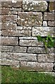
10
Ordnance Survey Cut Mark
This OS cut mark can be found on the wall east side of Inglewood Road. It marks a point 173.277m above mean sea level.
Image: © Adrian Dust
Taken: 14 Sep 2022
0.17 miles