IMAGES TAKEN NEAR TO
Frenchfield Gardens, PENRITH, CA11 8TX
Introduction
This page details the photographs taken nearby to Frenchfield Gardens, CA11 8TX by members of the Geograph project.
The Geograph project started in 2005 with the aim of publishing, organising and preserving representative images for every square kilometre of Great Britain, Ireland and the Isle of Man.

There are currently over 7.5m images from over14,400 individuals and you can help contribute to the project by visiting https://www.geograph.org.uk
Image Map
Images are licensed for reuse under creativecommons.org/licenses/by-sa/2.0
Notes
- Clicking on the map will re-center to the selected point.
- The higher the marker number, the further away the image location is from the centre of the postcode.
Image Listing (14 Images Found)
Images are licensed for reuse under creativecommons.org/licenses/by-sa/2.0
Image
Details
Distance
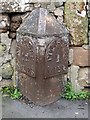
3

Victorian wall postbox at Carleton Village
Box no CA22 2SD is mounted in the roughcast side wall of the Cross Keys Inn, in Frenchfield Road which follows the line of the original Roman route and later A66 across the Pennines from Scotch Corner and Brough, but is no longer a through road to the east. For the location, see Roger Templeman's photo Image Collections are made at 9am from Mondays to Fridays and 7am on Saturday.
Image: © Tiger
Taken: 21 Aug 2018
0.12 miles
4
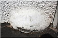
Benchmark on boulder embedded in wall of The Cross Keys
Ordnance Survey rivet benchmark described on the Bench Mark Database at http://www.bench-marks.org.uk/bm68669. The rivet is covered with pebbledash but the associated arrow cuts can be seen.
Image: © Roger Templeman
Taken: 3 Jul 2015
0.12 miles
5
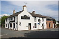
The Cross Keys public house, Carleton Avenue
There is an OS benchmark Image on a boulder at the base of the pebbledashed pub wall where the new stone extension abuts. There was an 1844 benchmark (see http://www.bench-marks.org.uk/bm67107 ) on the pub when it was known as the Odd Fellows Arms.
Image: © Roger Templeman
Taken: 3 Jul 2015
0.12 miles
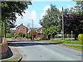
7
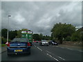
Minor road on north side of Carleton Hall Farm
Image: © Roger Templeman
Taken: 3 Jul 2015
0.16 miles
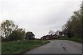
9
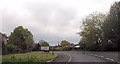
Old Milepost by the former A66, Carleton, Penrith
Metal post with attached metal plates by the UC road (was A66), in parish of PENRITH (EDEN District), Carleton Road, West of Frenchfield, near a barn, back of footpath, against stone wall, on East side of road. Appleby plate, erected by the Brough & Eamont Bridge turnpike trust in the 19th century.
Inscription reads:-
: APPLEBY / 12 / MILES : : BOWER / PRNR : : PENRITH / 1 / MILE :
Carved benchmark on front edge.
Milestone Society National ID: CU_PRAP01.
Image: © CF Smith
Taken: 13 Dec 2005
0.20 miles
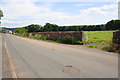
10
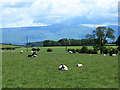
Field with sheep at Carleton
Cross Fell Image dominates the horizon.
Image: © Oliver Dixon
Taken: 11 Jun 2014
0.20 miles