IMAGES TAKEN NEAR TO
Maple Drive, PENRITH, CA11 8TU
Introduction
This page details the photographs taken nearby to Maple Drive, CA11 8TU by members of the Geograph project.
The Geograph project started in 2005 with the aim of publishing, organising and preserving representative images for every square kilometre of Great Britain, Ireland and the Isle of Man.

There are currently over 7.5m images from over14,400 individuals and you can help contribute to the project by visiting https://www.geograph.org.uk
Image Map
Images are licensed for reuse under creativecommons.org/licenses/by-sa/2.0
Notes
- Clicking on the map will re-center to the selected point.
- The higher the marker number, the further away the image location is from the centre of the postcode.
Image Listing (2 Images Found)
Images are licensed for reuse under creativecommons.org/licenses/by-sa/2.0
Image
Details
Distance
1
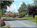
Carleton Road at Winter's Park
In 1844 when there were open fields on the right hand side of the road the Ordnance Survey cut a benchmark http://www.bench-marks.org.uk/bm67108 on a gatepost here. Now new walls and houses.
Image: © Roger Templeman
Taken: 3 Jul 2015
0.09 miles