IMAGES TAKEN NEAR TO
Parklands Crescent, PENRITH, CA11 8SL
Introduction
This page details the photographs taken nearby to Parklands Crescent, CA11 8SL by members of the Geograph project.
The Geograph project started in 2005 with the aim of publishing, organising and preserving representative images for every square kilometre of Great Britain, Ireland and the Isle of Man.

There are currently over 7.5m images from over14,400 individuals and you can help contribute to the project by visiting https://www.geograph.org.uk
Image Map
Images are licensed for reuse under creativecommons.org/licenses/by-sa/2.0
Notes
- Clicking on the map will re-center to the selected point.
- The higher the marker number, the further away the image location is from the centre of the postcode.
Image Listing (3 Images Found)
Images are licensed for reuse under creativecommons.org/licenses/by-sa/2.0
Image
Details
Distance
1
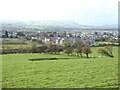
A prospect of Penrith
With the distant Lake District fells somewhat obscured by murk.
Image: © Oliver Dixon
Taken: 7 Oct 2020
0.20 miles
2
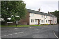
Friars Terrace at junction with Friars Rise
There is an OS benchmark Image on the wall behind the street name sign
Image: © Roger Templeman
Taken: 14 Jul 2015
0.23 miles
3
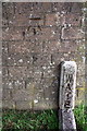
Water marker and benchmark on wall of Friars Terrace
Ordnance Survey cut mark benchmark described on the Bench Mark Database at http://www.bench-marks.org.uk/bm69100
Image: © Roger Templeman
Taken: 14 Jul 2015
0.23 miles