IMAGES TAKEN NEAR TO
Maidenhill, PENRITH, CA11 8SH
Introduction
This page details the photographs taken nearby to CA11 8SH by members of the Geograph project.
The Geograph project started in 2005 with the aim of publishing, organising and preserving representative images for every square kilometre of Great Britain, Ireland and the Isle of Man.

There are currently over 7.5m images from over14,400 individuals and you can help contribute to the project by visiting https://www.geograph.org.uk
Image Map
Images are licensed for reuse under creativecommons.org/licenses/by-sa/2.0
Notes
- Clicking on the map will re-center to the selected point.
- The higher the marker number, the further away the image location is from the centre of the postcode.
Image Listing (6 Images Found)
Images are licensed for reuse under creativecommons.org/licenses/by-sa/2.0
Image
Details
Distance
1
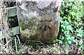
Benchmark on gatepost at field gateway on NE side of Maidenhill Road
Ordnance Survey cut mark benchmark levelled at 222.101m above Newlyn Datum in 1972
Image: © Luke Shaw
Taken: 18 Sep 2020
0.16 miles
2
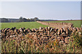
Stone walls
Well maintained dry stone walls form most of the field boundaries in this area.
Image: © Richard Dorrell
Taken: 11 Sep 2014
0.19 miles
3
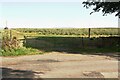
Field gateway on NE side Maidenhill Road at Toddles Hill
There is an Ordnance Survey benchmark Image on the inside face of the right hand gatepost
Image: © Luke Shaw
Taken: 18 Sep 2020
0.20 miles
4
A road, Penrith
Passing the poultry sheds at Greengill Head.
Image: © Andrew Smith
Taken: 22 May 2013
0.23 miles
5
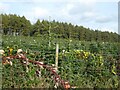
Inglewood Christmas Trees
Extensive plantation of Nordmann Fir on the Inglewood estate.
Image: © Oliver Dixon
Taken: 7 Oct 2020
0.23 miles
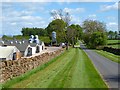
6
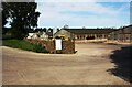
A.J.Forster Beaver Lodge poultry farm, Maidenhill Road
Image: © Luke Shaw
Taken: 18 Sep 2020
0.24 miles